George Thomas McDonald (1835-1915)
Pioneering surveyor in Victoria and Queensland 1858-circa 1913
Prepared by Laurie McLean, October 2023
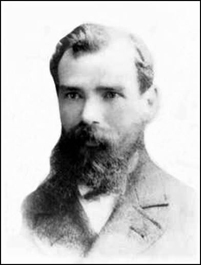
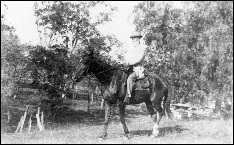
George Thomas McDonald.
Edited image from Chris Gill on a family tree on the Ancestry web site.
Scottish-born George McDonald was a surveyor in Victoria and Queensland between 1858 and 1913 or 1914. Over this more than half a century period, he spent much of his time surveying in the field. An exception was his time as a District Surveyor based at Castlemaine from mid-1869 to early 1878 when he undertook more of an administrative role. Peers described George McDonald as one of the pioneers of civilization who spent many years surveying the virgin acres of Queensland; in 1904 he was considered one of the most experienced surveyors in that State. George McDonald was also desribed as an honest workman and a genial, kindly gentleman. George McDonald and his Australian-born wife Amelia Margaret (Amy) née Mitchell were the parents of 8 children; 6 of whom reached adulthood and made outstanding contributions to Australian society. The following article briefly traces the life and achievements of George McDonald and some of his family members.
Early life
George Thomas McDonald was born at Dumfries on 31 May 1835. Dumfries is on the River Nith in south-western Scotland about 16 kilometres north of Solway Firth that joins the Irish Sea and about 20 kilometres north of the border with England. George was the first of the 7 children of Scottish-born James McDonald (circa 1809 or 1811-1887) and his Irish-born wife Isabella McDonald née Bustard (1812-1877).
On an 1851 England Census, 15-year old George McDonald was listed as residing with his parents and siblings at Newcastle-under-Lyme and being occupied as a labourer. Unfortunately, nothing else of George’s early life, education, or professional training in the United Kingdom was discovered during research for this article.
George McDonald’s father, James McDonald was born in Scotland (possibly at Leith, now a suburb of Edinburgh) and died at 3 Castle Street Bevois Town in Southampton on 18 October 1887, at around 78 years of age. The port city of Southampton is on the south coast (English Channel coast) about 110 kilometres south-west of London. James McDonald was a boot and collar maker by trade.
In May 1825, James McDonald enlisted in the Corps of Royal Sappers and Miners at Woolwich then in Kent (now south-east London) and is said to have served until July 1840; although some Census records indicate he may have served into the 1850s. (The Corps of Royal Sappers and Miners was unified with the Royal Corps of Engineers in 1856.)
In the late 1830s until late in 1840, James McDonald served in the north of Ireland. When their second son James was baptised in February 1841, James McDonald and his wife Isabella McDonald were residing at Cowbridge and James was with the Royal Sappers and Miners. Cowbridge is a market town in the Vale of Glamorgan in Wales and about 20 kilometres west of Cardiff.
On an 1841 Census, the then 30-year old James McDonald was listed as serving in the Army and as residing at Langeinor (Llangeinor) in Wales with his wife Isabella and their 3 children. (Llangeinor is in the Garw Valley about 30 kilometres north-west of Cardiff.) On an 1851 Census, the then 41-year old James McDonald was listed as a Private, Royal Sappers and Miners and as residing at Newcastle‑under‑Lyme with his wife Isabella and their 6 children. (Newcastle‑under‑Lyme is adjacent to Stoke-on-Trent and is located between Liverpool and Birmingham.)
On an 1871 Census, the then 62-year old James McDonald was listed as a timekeeper with Ordnance Survey* and also a Chelsea pensioner; residing at Southampton with his wife Isabella and 5 of their children. (From November 1841, Ordnance Survey was located in London Road Southampton close to the junction with The Avenue. From 1692 until 1955, all British Army pensions were administered by and paid from the Royal Hospital Chelsea, hence Army pension recipients were known as Chelsea pensioners.)
*(Ordnance Survey is Great Britain’s national mapping organisation, now a government civilian agency, headquartered at Southampton since 1841. Ordnance Survey was founded in 1791 for military purposes, namely to map Scotland in the wake of the Jacobite rising of 1745.)
George McDonald’s mother Isabella McDonald née Bustard (1812-1877) was born at Garrison; a small village near the north-eastern shore of Lough Melvin in County Fermanagh in the far south-west of what is now Northern Ireland; the border between the 2 Irelands now runs through part of Lough Melvin. Isabella McDonald died at Southampton at 64 years of age.
George McDonald’s siblings
As mentioned, George Thomas McDonald had 6 younger siblings; a sister and 5 brothers, namely:
· Jemima (Mina Jane) McDonald (1838-1910) who was born in Ireland, she became a dressmaker and died at Southampton. At Southampton in October 1877, Jemima married Robert William Lee (1853-1940); they had 1 child.
· James McDonald (1840-1878) who was born in County Fermanagh, Ireland in October 1840 (baptised in Wales in February 1841). In 1857, at age 17 years and with older brother George, he came to Melbourne as a surveyor. In Victoria in 1863, James married Irish-born Hermina Julianna Cox (1843-1931), they had 4 children but divorced circa 1876. James McDonald worked as a surveyor in Victoria and New South Wales including at Jamieson, Benalla, Boara (near Young), Sale, and in the Kerang area. James McDonald died suddenly at his survey camp near Kerang on 10 April 1878; he was 37 years of age.
· Thomas McDonald (1843-1872) who was born at Bradford near Leeds in Yorkshire and about 280 kilometres north-west of London. Thomas died at Southampton at about 29 years of age, he was then a draughtsman with Ordnance Survey.
· William Wallace McDonald (1846-1927) who was born at Killinghall just north of Harrogate in Yorkshire and about 300 kilometres north-west of London. William became a Sergeant, Royal Engineers, Ordnance Survey. In 1870 at Southampton, William married Grace Boyle (1847‑1929); they had 6 children. By 1891 William was a draughtsman with Ordnance Survey. William Wallace McDonald died on 27 December 1927 at Southampton, he was about 81 years of age.
· Robert McDonald (1848-1874) who was born at Pateley Bridge in the Harrogate district of Yorkshire. On an 1871 Census, Robert was listed as a 22-year old plotter with Ordnance Survey and as residing with his parents and other family members in Southampton. Robert McDonald died at Southampton at around 26 years of age.
· Alexander McDonald (1851-1901) who was born at Osmotherly, Yorkshire during October 1851. On an 1871 Census, Alexander was listed as a 19‑year old clerk with Ordnance Survey and as residing with his parents and other family members in Southampton. In October 1878, at St George's parish church in Hanover Square London, Alexander married Annabel Laura Rose (1858‑1934); they were to have 5 children. Alexander McDonald died on 6 August 1901 at Camberwell in Greater London; he was 49 years of age.
George McDonald’s arrival in Victoria 1857
The then 22-year old George McDonald was one of 3 young surveyors onboard Invincible that arrived at Hobson’s Bay (Williamstown) on 23 December 1857. His surveyor travelling companions were his younger brother James McDonald (1840-1878), then age 17 years, and Walter Greenlaw, then age 23 years. These surveyors were among the 279 steerage passengers who departed Liverpool on 5 October 1857; there were also 5 cabin passengers onboard Invincible for that voyage.
Invincible (of some 1509‑1671 tons) was a clipper packet ship of the Black Ball Line and was under the command of Captain Henry Johnston for the October‑December 1857 voyage. These types of sailing vessels were designed for fast passages. Invincible’s 1857 passage from Liverpool to Melbourne had taken some 80 days which was considered to be fairly fast. A typical clipper voyage from Plymouth to Sydney would take about 100 days. However, in 1868-1869, Thermopylae made the passage from London to Melbourne in a record time of just 61 days.
Apparently, George McDonald had obtained employment as a Temporary Assistant Surveyor with the Surveyor-General's Department of the Colony of Victoria prior to leaving the United Kingdom on 5 October 1857. As discussed at Permanent appointment below, in the Victoria Government Gazette of 26 February 1867, it was noted that George McDonald was employed by the Department from August 1857. However, he was to remain a temporary employee until January 1867.
No information was discovered on George McDonald’s work for the Department of Crown Lands and Survey in Victoria during the late 1850s. It was reported that in 1860, George McDonald surveyed in the Cape Schank area near the southern end of the Mornington Peninsula and around 75 kilometres from Melbourne. Presumably this was prior to commencing the McDonald’s Track survey that year; which is further discussed below. (The Cape Schanck run covered over 9 600 acres (over 3 885 hectares) and was taken up in 1838 by Charles Campbell (1809-1888) from Sydney. Early pastoralist John Barker together with his brother, Edward Barker held the run from 1840 until 1884.)
Early government survey organisation in Victoria from 1851
In the then Colony of Victoria, the Surveyor-General's Department operated from 1851 to 1857. In 1857, the Department of Crown Lands and Survey was established under the Board of Land and Works; in 1964 the Department ceased to be controlled by the Board.
While being recruited and then later working as a Government Surveyor in Victoria, George McDonald would have served under 4 Surveyors-General, namely George Christian Darbyshire, Clement Hodgkinson, Charles Whybrow Ligar and Alexander John Skene. Short outlines of each of these gentlemen are provided below.
George Christian Darbyshire (1820-1898) was born in England and became a civil engineer, railway engineer and surveyor before coming to Melbourne with his wife in 1853. He became Engineer of Construction and a District Surveyor at Williamstown in 1854. Darbyshire was appointed Deputy Surveyor-General of Victoria on 9 April 1857 and acted until July 1857.
Darbyshire was also Chief Engineer of the Victorian Railways in 1856-1857 and again during 1891-1898. He was appointed to the Board of Science in June 1858, and as Territorial Magistrate for Wyndham in April 1865. (Incorporated in 1862, the Wyndham District was to the west of Melbourne around today’s City of Werribee.)
In the 1860s and 1870s, Darbyshire was a licensed surveyor undertaking township and rural surveys for both Government and private practice. He was belived to have been involved with surveying part of the Victoria-South Australia border, and was responsible for the Town Plan of Lorne in 1871.
Clement Hodgkinson (1818-1893) was an English naturalist, civil engineer, explorer and surveyor. He came to New South Wales around 1839 and purchased a cattle station at Kempsey. Later he surveyed and explored north‑eastern areas of New South Wales as far as Moreton Bay. In early 1841 he explored the upper reaches of the Nambucca and Bellinger Rivers, followed the Macleay, Clarence, Hastings, Richmond and Tweed River valleys, visited Port Macquarie, Brisbane and Moreton Bay. After returning to England, he published an account of his explorations in 1845, Australia, from Port Macquarie to Moreton Bay.
Hodgkinson again travelled from England to Victoria around 1850. In 1852, he joined the Survey Office as a draftsman and was appointed as a District Surveyor in 1855. As part of his surveying duties, the township of Warrandyte was laid out in 1856. Hodgkinson was involved in a number of significant civic projects and public parks in Melbourne including:
· In 1857, he designed St Vincent Gardens in Albert Park.
· He designed and oversaw the development of the Fitzroy Gardens in 1859.
· In 1862 he prepared a plan for the Flagstaff Gardens.
· He designed the Treasury Gardens in 1867.
Hodgkinson was Victoria’s Assistant Commissioner of Crown Lands and Survey from 1861 to 1874. He was Acting Surveyor-General of Victoria from 28 October 1857 until Charles Ligar’s appointment in 1858. Hodgkinson had a number of other significant appointments in Victoria.
Charles Whybrow Ligar (1811–1881) attended the Royal Military Academy at Sandhurst from the age of 13 years and later held a commission in the Royal Corps of Engineers. He resigned his commission to become a surveyor and cartographer with the British Ordnance Survey. He was Senior Civil Assistant, for the Ordnance Survey of Ireland in 1840 and was Surveyor-General of New Zealand from 1842 to 1856. Ligar was Surveyor-General of the Colony of Victoria from 1858 to September 1869 when he resigned with a pension of £500. Ligar was born in Ceylon (now Sri Lanka) and died in Texas USA. In 1839, Ligar married Irish-born Grace Hanyngton (1808-1868), grand niece of the Earl of Charlemont. He remarried after his first wife’s death.
Alexander John Skene (1820-1894) was born in Aberdeen, Scotland. He was educated at the University of Aberdeen; gaining a Master of Arts degree in 1838. Skene practised surveying soon after he arrived in Victoria in 1839. He became an official surveyor with the Grant District Council in 1843 (then one of the 2 councils in the Port Phillip District), and a government district surveyor in October 1848.
Skene was appointed Acting Surveyor-General in 1868 and in September 1869, replaced Charles Whybrow Ligar as Surveyor-General of Victoria; apparently Ligar had become increasingly unpopular and some prominent politicians had demanded his removal. In the mid-1870s, Skene directed the preparation of an accurate map of Victoria at a scale of 8 miles to the inch (1: 506 880 scale). The Map of Victoria of 15 June 1876, was drafted by GA Windsor and depicts McDonald’s Track. It can be accessed from the National Library of Australia at this link. Skene remained Surveyor-General until 1886; he died at his home Ellesmere in St Kilda in 1894 at 74 years of age and was survived by 4 of his children.
Trial survey for a line of road to Gippsland 1860-1862 (McDonald’s Track)
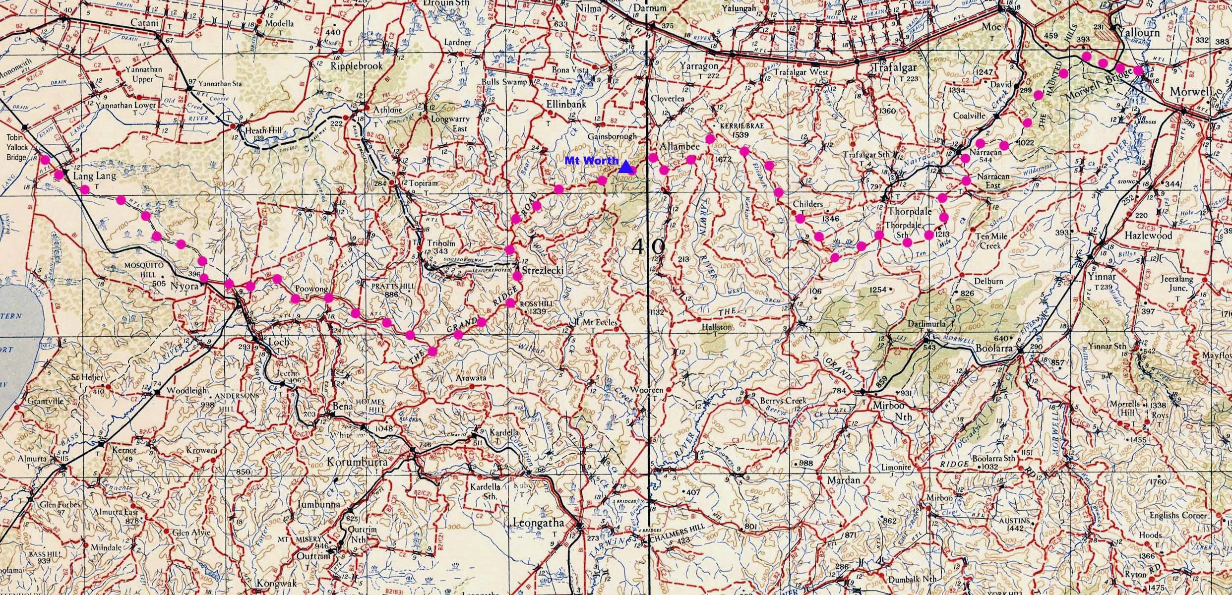
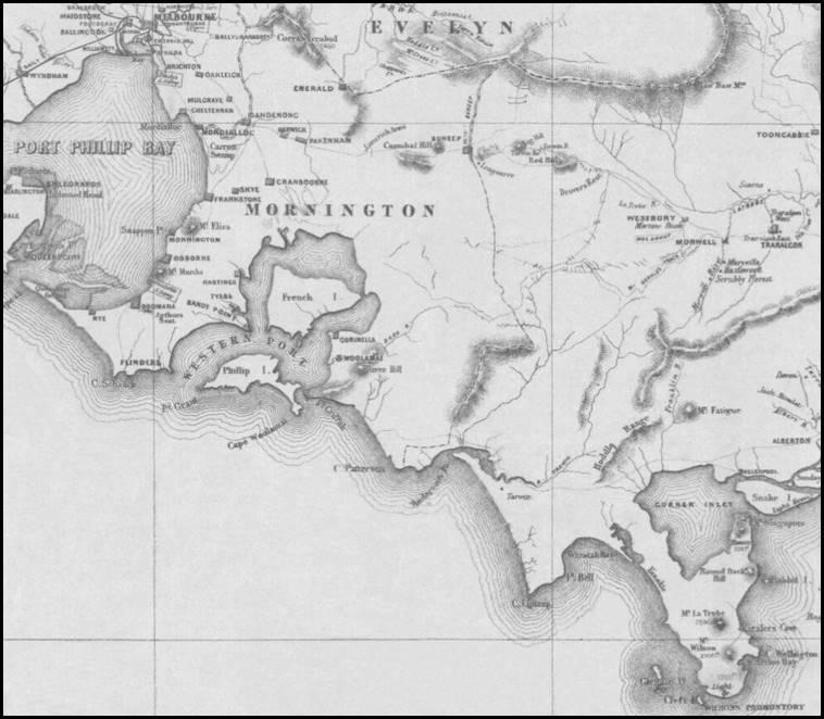
Between 1860 and late 1862, Temporary Assistant Surveyor George McDonald undertook a trial survey to establish a new line of road to Gippsland from the Lower Gippsland road (now the South Gippsland Highway) at Tobin Yallock (near Lang Lang) to near Morwell Bridge on the Upper Gippsland road (now the Princes Highway). The survey line became known as McDonald’s Track; it covered a distance of some 68 miles (about 110 kilometres). One of the objectives of the new line of road was to establish a route to Gippsland that avoided The Great Marsh or Great Swamp, names then given to the Koo Wee Rup swamp and the Moe swamp then erroneously thought to be contiguous; see Map 1 below.
As discussed in his Letter No 3 at Attachment A, George McDonald found that the Koo Wee Rup and Moe swamps were not connected and were much smaller in extent than previously thought. He talked of instead of swamp, finding good soils in dry and gently rising hill country with a succession of wide valleys. Presumably, McDonald was referring to the later rich farming country in what became known as the Warragul and Drouin districts.
McDonald carried out his trial survey under instructions from Charles Ligar, the then Surveyor-General of the Colony of Victoria. Apparently, Ligar’s instructions included for McDonald to select a route along the ridges of the Strzelecki Ranges.
As a consequence, McDonald later noted there were no creek crossings along the route he had surveyed. He avoided the numerous small streams that drain the southern slopes of the western section of the Strzelecki Ranges as well as several major rivers in the area.
These rivers included the Bunyip (then called the Buneep River) that enters Western Port Bay south-west of Koo Wee Rup and was well to the west of McDonald’s survey route which was to the south of the Lang Lang River watershed. The survey route was to the north of the Bass River that rises about 2 kilometres north-west of Korumburra. The watersheds of these 2 rivers are depicted on Map 2 below.
McDonald’s trial survey route also went to the north of the West Branch of the Tarwin River that rises to the south-east of Mt Worth. McDonald’s route also avoided crossing the Narracan Creek that rises north‑west of Childers and drains into the La Trobe River north of Moe. McDonald’s route kept to the west of the Morwell River that rises in the eastern section of the Strzelecki Ranges.
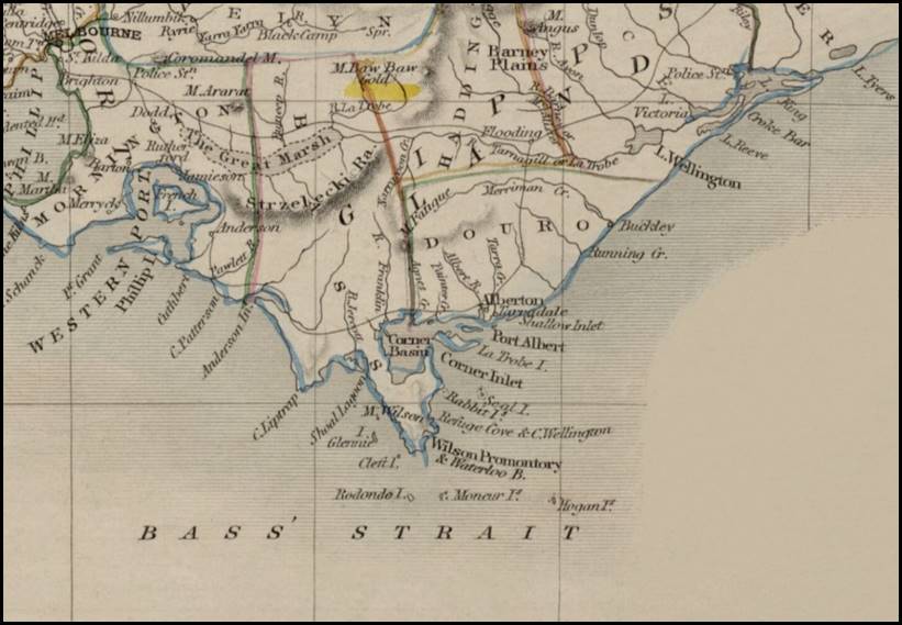
Map 1: An edited extract from the circa 1851 Victoria or Port Phillip map
drawn and engraved by John Rapkin (John Tallis & Company, London and New York) showing the then erroneously thought extent of The Great Marsh.
Downloaded from the National Library of Australia web site Bib ID: 9707, Object-232646335.
Along his trial survey route McDonald was said to have started cutting a dray track of some 7 feet (2.1 metres) in width but the track narrowed from 4 or so miles short of Mt Worth onwards. Mt Worth is depicted on Map 4 below. It has an elevation of 507 metres on the Australian Height Datum and was the highest point on McDonald’s route.
Of course, McDonald did not work alone. It was said that he worked with a party of 5 men; one of whom was a John Carson. For nearly 2 years, McDonald and his survey party had a task of great difficulty due to the irregularity of the Strzelecki Ranges, the dense scrub, and the heavy tree cover in parts with some of the Mountain Ash (Eucalyptus regnans) reaching over 250 feet (about 75 metres) in height. Some extent of the irregularity of the country can be gleaned from Map 3 below that shows the twisting nature of McDonald’s route near the later township of Poowong.
During the survey, McDonald and his men worked and camped in hitherto untouched country. Initially at least, they had to bring their supplies in by cart from Cranbourne. This may have been the reason for cutting a dray track along their route until near Mt Worth. George McDonald described the country he encountered during his 1860-1862 trial survey in his Lettters Nos 1 and 3 that are provided at Attachment A.
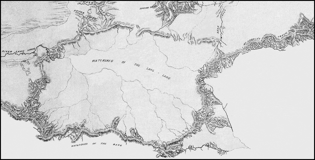
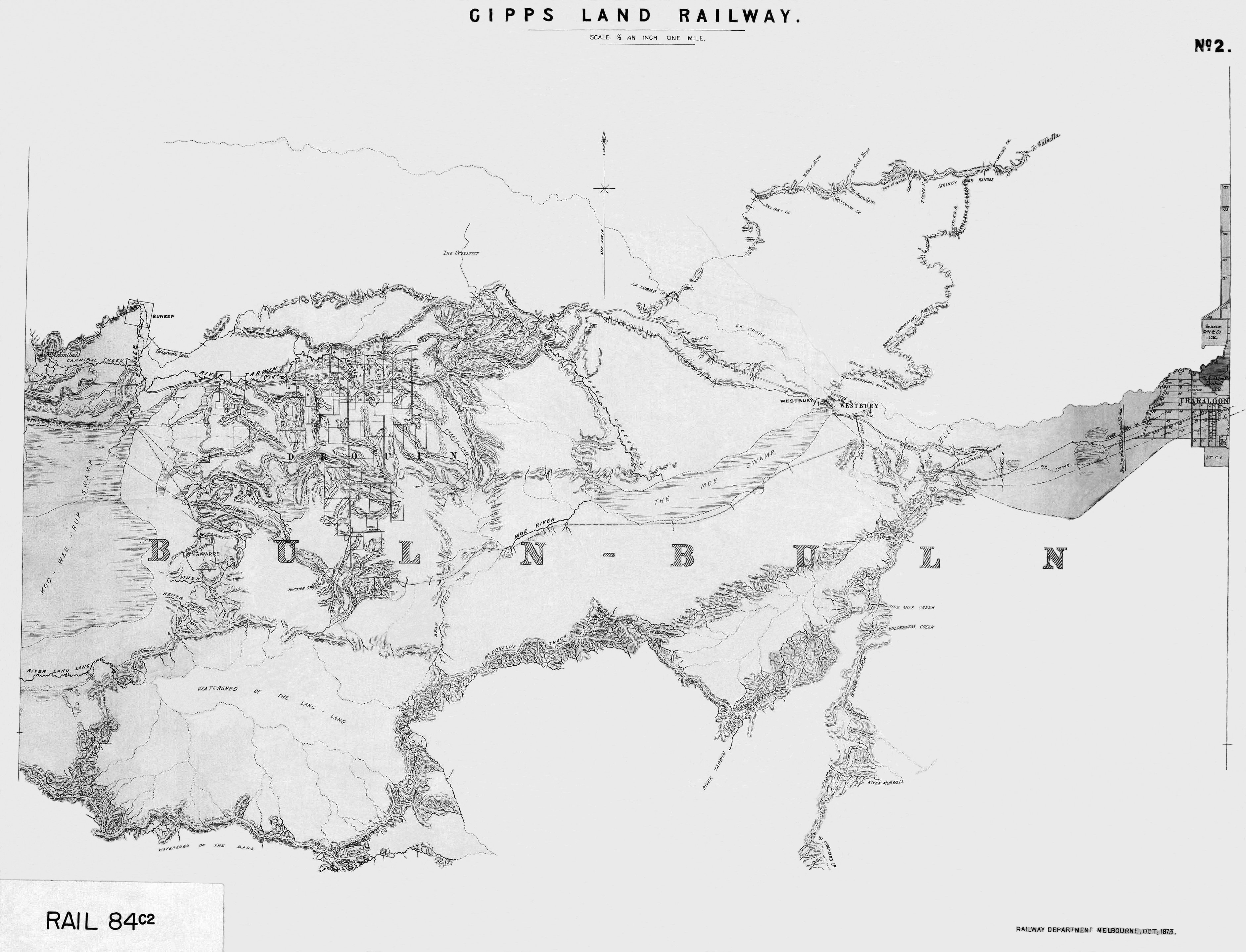
Map 2: A section of McDonald’s Track on an edited extract from a Gipps Land Railway No 2 map
prepared by the Railways Department, Melbourne in October 1873. Obtained from the State Library of Victoria, Record ID 9920268323607636.
The full map can be accessed and zoomed at this link.
In his Letter No 2 at Attachment A, McDonald talked of finding a seam of very good quality (black) coal (that burned very well) on the northern side of the Dividing Range (western Strzelecki Ranges). George McDonald had discovered black coal in the Narracan Creek valley, near what later became Narracan about 10 kilometres south of Moe.
The first coal mining lease in the Narracan Valley was taken up in 1864 but mining operations did not commence until 1879. Over the following years there were numerous small and medium scale black coal mining ventures. The last black coal mining operations in the Narracan Valley ceased in the early 1930s.
The approximate position of McDonald’s Track on Map 4 below was annotated by Paul Wise using digital terrain model analysis to avoid crossing any water courses as well as an overlay of the 1873 Gipps Land Railway No 2 map that can be zoomed from the link at Map 2 above.
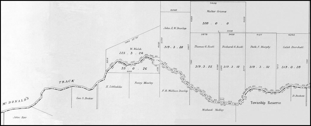
Map 3: A section of McDonald’s Track at Poowong from an edited extract from an 1877 Parish of Poowong plan
prepared by the Department of Crown Lands and Survey; downloaded from the State Library of Victoria web site, Record ID 9915758253607636.
The full map can be accessed and zoomed at this link.
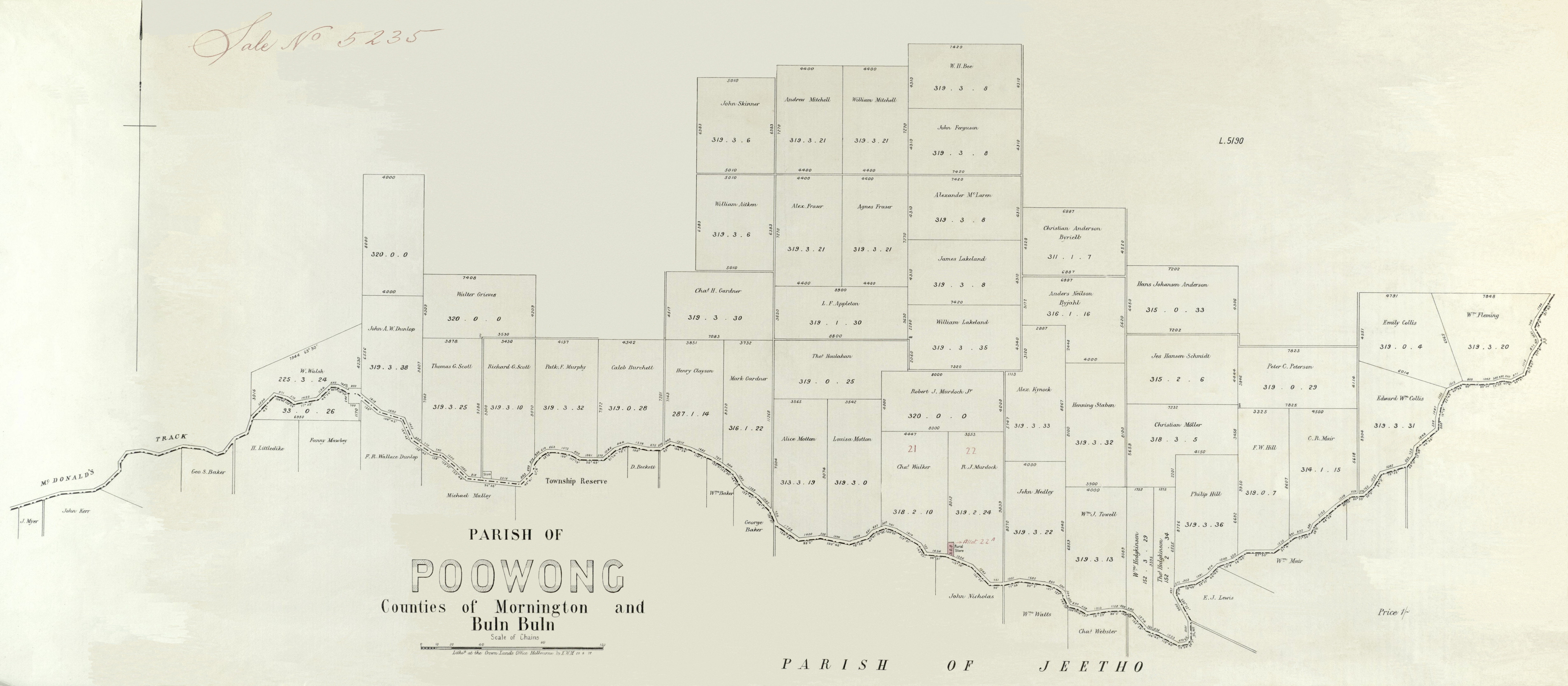
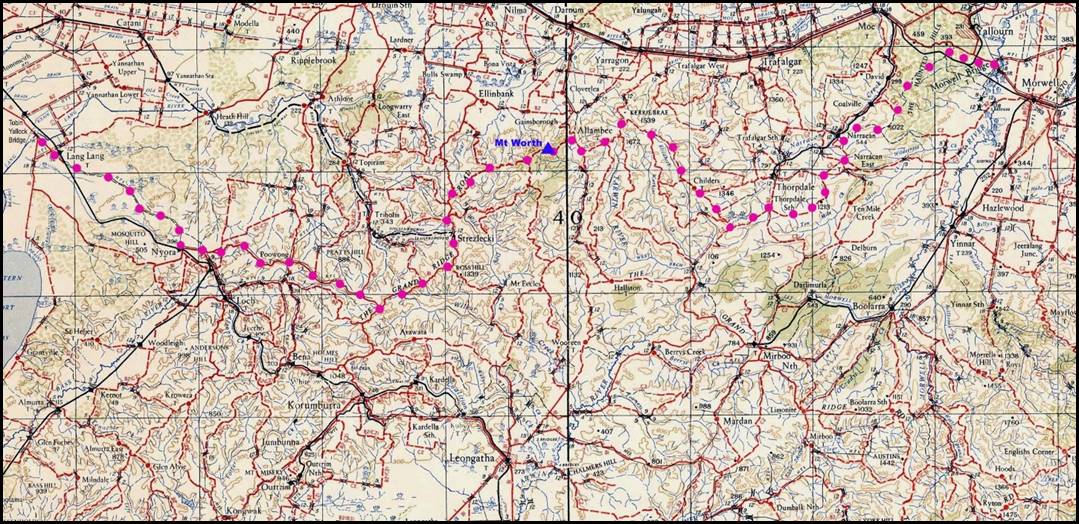
Map 4: Approximate position of McDonald’s Track
depicted by ![]() dots
dots
on an edited extract from a 1942 Warragul second edition J 55/10-11 topographic map sheet in the 4 mile (1:253 440 scale) strategic series
prepared by LHQ (Aust) Cartographic Company; downloaded from the National Library of Australia web site, Bib ID: 5720665.
This map extract can be zoomed at this link.
On Map 5 below McDonald’s Track is depicted on an edited extract from the 1865 Gazetteer Map of Victoria. Here it can be seen that after leaving the Haunted Hills, George McDonald kept his trial survey line to the south of the then coach route (called the Upper Gippsland road) for the final 2 miles or so (about 3 kilometres) into Morwell Bridge.
Map 5: McDonald’s Track depicted on an edited extract from the Gazetteer Map of Victoria prepared by the Department of Crown Lands and Survey, Melbourne on 31 March 1865.
National Library of Australia Call Number MAP RM 1026.
The full map can be accessed and zoomed at this link.
About Tobin Yallock (Lang Lang)
In 1860, George McDonald established his survey camp at Yallock; presumably on the Yallock pastoral lease (that was to the north of Western Port Bay) and had been taken up in 1839 by Robert Jamieson and Samuel Rawson. In 1851, Scottish-born John Mickle (1814-1885), English-born John Bakewell (1807‑1888), and Scottish‑born William Lyall (1821-1888) started a business partnership by acquiring the Yallock run of 1 920 acres (about 777 hectares). The run was also called Tobin Yallock or Torbinurruck run. The Yallock run was located on Yallock Creek that flows into Western Port Bay between present day Koo Wee Rup and Lang Lang. The trio added more properties before dissolving their partnership and equally dividing the land in December 1856. Lyall received the Yallock run and on it, to the west of Tooradin, commenced building Harewood in 1857; it was completed in 1868 and is still standing.
The Lyall family then moved in from their 212 acre (about 86 heactares) estate Frogmore in eastern Melbourne in the later named suburb of Carnegie. (The ornate dwelling Frogmore at 1 Wahgoo Road Carnegie (since demolished) was built for Archibald McLaurin in 1889-1890, about 20 years after he purchased the estate from William Lyall.)
By 1860, the Tobin Yallock settlement had developed near the bridge over the Lang Lang River at the junction of the tracks to the Grantville and the Poowong districts. The bridge over the Lang Lang River was about 5 kilometres north of the river mouth at Western Port Bay and about 70 kilometres south-east of Melbourne on the then Lower Gippsland road that is now the South Gippsland Highway. In 1890, the South Gippsland railway line reached Lang Lang (initially named Carrington). The railway station, was about a mile east of Tobin Yallock village. Gradually, the settlement moved to the vicinity of the railway station. After the the Tobin Yallock post office and the store housing it was burnt down in 1892, the post office and name Lang Lang was transferred to the railway station settlement.
About Morwell Bridge
After 1844, pastoral runs were taken up along the Morwell River which flows from the eastern section of the Strzelecki Ranges into the Latrobe River about 130 kilometres south‑east of Melbourne. A bridge was built over the Morwell River in 1847 about 5 or 6 kilometres south of its confluence with the La Trobe. Circa 1858, a hotel was established at the crossing which became known as Morwell Bridge. By 1865, Morwell Bridge was a staging post on the coach road from Melbourne to Sale.
Initially on the east side of the Morwell River, later, most of the settlement at Morwell Bridge was on the western side of the River. At its peak Morwell Bridge had about 50-60 houses and about 350 people as well as schools, shops and churches. When the railway line from Sale to Oakleigh opened in 1878, a railway station was sited about 3 kilometres east of Morwell Bridge and settlement around the station developed into today’s city of Morwell. Morwell Bridge township ceased to exist in the early 1960s when the then State Electricity Commission of Victoria completed its acquisition of all the propterties in the town to expand the Yallourn open-cut brown coal mine.
McDonald’s Track after 1862
Today, parts of McDonald’s Track remain named on maps (including the on‑line Google Maps) around Lang Lang, Poowong East, Mount Worth, Childers, Thorpdale and Narracan. However, a major road was never constructed along the route.
While difficulties with water and supply of feed for stock along the surveyed track were no doubt limiting factors so too was the difficult hilly terrain, scrub and timber cover that necessitated a torturously winding track for much of its 110 kilometres length.
Nevertheless, in a government advertisement on page 2 of Melbourne’s The Argus newspaper for 13 May 1865, the Roads and Bridges Office in Melbourne invited tenders for clearing and cutting sidelings on about 25 miles of McDonald's Track between Tobin Yallock and the Morwell. Also, on page 3 of the Sale newspaper Gippsland Times for 15 May 1866, it was reported that John Mahoney and Company were gazetted as the succesful tenderers for additions to the contract on McDonald's Track with a contract price of £34 0s 10d.
Permanent appointment with Department of Crown Lands and Survey
On page 426 of the Victoria Government Gazette, No 23, on 26 February 1867, the appointment was promulgated of George T McDonald to the position of Assistant Surveyor. This was classified as a 4th class appointment to the Professional Division in the Civil Service of the Colony of Victoria and took effect from 1 January 1867.
McDonald’s appointment was made by the Governor of the Colony of Victoria on the advice of the Executive Council. The Gazette notice was signed by James MacPherson Grant (1822-1885), the then President of the Board of Land and Works and Commissioner of Crown Land, a former (elected) member of both the Legislative Assembly and (later) the Legislative Council. The then Governor was the Third Viscount Canterbury, Sir John Henry Thomas Manners-Sutton (1814‑1877). The Gazette notice mentioned that McDonald had special qualifications for the situation and was the oldest temporary surveyor in the Department having been employed from August 1857.
Marriage to Amelia Margaret Mitchell 1869
On 24 November 1869, George Thomas McDonald married Amelia Margaret (Amy) Mitchell (1846-1939) at Barfold; the Reverend Percy Smith officiated. George was then 35 years of age and Amy was 23 years of age. Barfold was established by Amy’s father on the east side of the Campaspe River on the Kyneton to Heathcote road about 15 kilometres north of Kyneton. George was then already said to be working as the District Surveyor for the Castlemaine district.
Amelia Mitchell was born at Barfold on 20 May 1846. She was the second of the 11 children of English-born Sir William Henry Fancourt Mitchell (1810‑1884) and his Glasgow-born wife Christina Mitchell née Templeton (1816‑1871). Sir William was knighted in 1875.
During his life, Sir William Mitchell had been a journalist, acting Colonial Secretary in Tasmania, grazier, company director, magistrate, chief commissioner of the Victoria Police (from 1851 to 1855), a postmaster-general in Victoria (from 1857 to 1858), and a Member of the Legislative Council; initially in 1856 and then from 1860 until his death in 1884 (he was President of the Council from 1870 until his death). Sir William died at his property Barfold on 24 November 1884; he was 73 years of age. He died of food poisoning, having eaten poisonous fish in Melbourne a few days earlier.
George and Amy McDonald were to have 8 children between 1872 and 1885; the first 5 were born at Castlemaine and the remaining 3 at Rocky Water Holes (Brisbane). Sadly 2 of the children died at a young age at Rocky Water Holes and another died of wounds during World War I. More information on the McDonald children is provided in Attachment B.
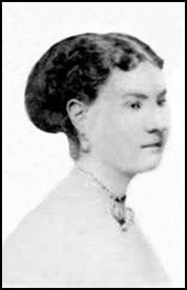
Amelia (Amy) McDonald née Mitchell.
Edited image from Chris Gill on a family tree on the Ancestry web site.
District Surveyor, Castlemaine circa 1869-January 1878
On 13 December 1869, George T McDonald was appointed Assistant Surveyor, Land Officer, and Collector of Imposts for the Castlemaine District vice Assistant Surveyor George Langford who was transferred to the Echuca District on the same date. This appointment was promulgated on page 1993 of the Victoria Government Gazette, No 70 on 17 December 1869. However, as mentioned above, George McDonald had already commenced duty as District Surveyor at Castlemaine when he married Amy Mitchell on 24 November 1869.
Further, this gazettal was not George McDonald’s formal appointment as the District Surveyor at Castlemaine. That appointment was promulgated on page 960 of the Victoria Government Gazette, No 35 of 22 May 1874 as follows: Civil Service Promotions GT McDonald, Assistant Surveyor of the 4th Class, Professional Service to be District Surveyor of the 3rd Class, vice AC Allan promoted, to date from 30 March 1874.
When stationed at Castlemaine from at least late 1869 to mid-1878, the McDonald family resided in the suburb of Monument Hill to the east of the town centre.
Among McDonald’s duties as District Surveyor at Castlemaine were frequent attendances at meetings of local land boards in the Castlemaine and wider district. Several Victorian newspapers during the 1870s reported McDonald’s attendance at local board meetings at Avoca, Castlemaine, Heathcote, Maldon and Kyneton. Usually these local land board meetings were held in the court house where District Surveyor McDonald presided together with at least one other eminent person such as a police magistrate, shire president or mining board chairman. For attendance at some local land board meetings, for example at Kyneton, George McDonald travelled from Castlemaine by train.
Local land boards considered applications under the Land Act relating to the granting of land as well as other land administration mattters including the forfeiture of Crown lands for non-payment of rents or other failures to meet lease or licence conditions. If satisfied with an application, the local board would make a recommendation accordingly to the Board of Land and Works in Melbourne for final determination.
At a local land board meeting at Maldon on 16 October 1873, 2 overlapping applications for the granting of a parcel of land were considered. One of the applications was granted subject to the excision of a school site. The other applicant admitted he did not peg out the land as he had previously stated. Mr McDonald questioned this applicant as to how he could reconcile his present statement with his earlier sworn declaration that he had marked out the ground.
The applicant replied, I dont know. Mr McDonald then called him out, reportedly saying: You have committed perjury and placed yourself in an awkward position. However, the unsuccesful applicant was allowed to go sheepishly out of court. (Reported on page 2 of The Tarrangower Times and Maldon, Newstead, Baringhup, Laancoorie and Muckleford Advertiser of 18 October 1873.)
Black Wednesday 1878
George McDonald lost his position as a government surveyor in Victoria in January 1878. On Wednesday 9 January 1878, the radical liberal ministry of then Premier Sir Graham Berry (1822–1904) dismissed many people from the upper echelons of the colony's civil service.
Among those dismissed were all judges of the county courts, courts of mines and insolvency courts; all police magistrates and wardens of goldfields; all coroners and deputy-coroners; 3 Crown prosecutors; and a number of senior departmental officers. A second round of dismissals on 24 January brought the total retrenched positions to nearly 400, but many of the people were subsequently reinstated.
Although known as Black Wednesday, the dismissals had been effective from the previous day and were promulgated in the Second Supplement to the Victoria Government Gazette, No 3 of 8 January 1878.
London-born Graham Berry was to serve 3 separate terms as Premier of the Colony of Victoria between 1875 and 1881. In 1877 and 1878, his government had much difficulty in its relations with the Legislative Council that Berry had unsuccessfully tried to reform. His government’s formal justification for the Black Wednesday dismissals was the need to conserve funds and carry out promised retrenchments.
However, several leading radicals including Berry spoke publicly of the sackings as revenge upon the Legislative Council through their friends. Thus being the son-in-law of Sir William Mitchell, the staunchly conservative President of the Council, apparently sealed George McDonald’s fate as a public servant in those difficult times. George McDonald was one of the 57 officers of the Department of Crown Lands and Surveys whose services were dispensed with on 8 January 1878. McDonald was not one of those who were subsequently reinstated; see McDonald’s Letter No 4 in Attachment A.
Move to Queensland 1878
On 16 September 1878, George McDonald, his wife Amy, their then 5 children and Mrs McDonald’s servant, arrived in Brisbane onboard the (680 gross tons) iron hull steam ship Alexandra from Sydney under the command of Captain Finlayson. (Reported on page 2 of The Brisbane Courier newspaper of 17 September 1878.)
Initially, the McDonald family settled into a comfortable home in Consort Street at Corinda in western Brisbane. (In 1937, softdrinks manufacturer and philanthropist George Marchant (1857-1941) gifted the site at Consort Street to the Queensland Society for Crippled Children that then mainly assisted young polio sufferers. Today the site is known as Montrose Park after Marchant’s Taringa home that he had gifted to the Society in 1933.)
Apparently, George McDonald had earlier journeyed to Brisbane before accompanying his family on their voyage there. The Brisbane Courier newspaper of Friday 13 September 1878, on page 2, kindly welcomed George McDonald to Queensland with the following words: We observe that Mr M'Donald, lately a district surveyor in Victoria, and one of the victims of Black Wednesday, has commenced the practice of his profession among us. We trust that Mr McDonald will have cause to be glad of what, at the time, must have seemed a serious disaster, and that he will find the Queensland public a better and more reliable employer than the Victorian Government.
On 14 August 1878, George Thomas McDonald was registered as an Authorised (Licensed) Surveyor in Queensland. On 17 August 1878, Mr George T McDonald (late District Surveyor, Victoria), was running the first of a series of advertisements in The Brisbane Courier newspaper as a licensed surveyor with land, engineering, and mining surveys effected. He practised from an office at 23 Queens Street Brisbane. These advertisements ran periodically until at least June 1880.
Residing in Brisbane 1878-circa 1910
After initially residing in Consort Street Corinda, by no later than 1880, the McDonald family resided at Lumeah in Rocky Water Holes (about 3 kilometres east of Corinda in western Brisbane). The township Rocky Water Holes took its name from a tributary of a branch of Oxley Creek in its northern catchment about a kilometre south of the Brisbane River. Rocky Water Holes now cross the Brisbane Golf Course. From circa 1870, the township of Rocky Water Holes, on the Ipswich road, became the first stop for Cobb and Co coaches on the Brisbane to Ipswich and Beaudesert run.
The name Rocklea was officially adopted in 1884 for the railway station that opened in 1885. In May 1885, the post office (that opened in 1866) and the houses and shops in the area originally known as Rocky Water Holes were renamed Rocklea. (Lumeah is a Tharawal (or Dharawal) word that is said to mean here I rest; the Dharawal people lived from Botany Bay as far south as the Shoalhaven River area on the New South Wales South Coast.)
Between, 1895 and 1905, Mrs GT McDonald of Lumeah was often mentioned in the social pages of the The Brisbane Courier newspaper. The McDonald family resided at Lumeah until at least early 1910. But electoral roll entries indicated that by 1912, George and Amelia McDonald were residing in Gladstone. However, while his family resided at Lumeah for around 30 years, George McDonald spent much of his time away from home carrying out field surveys.
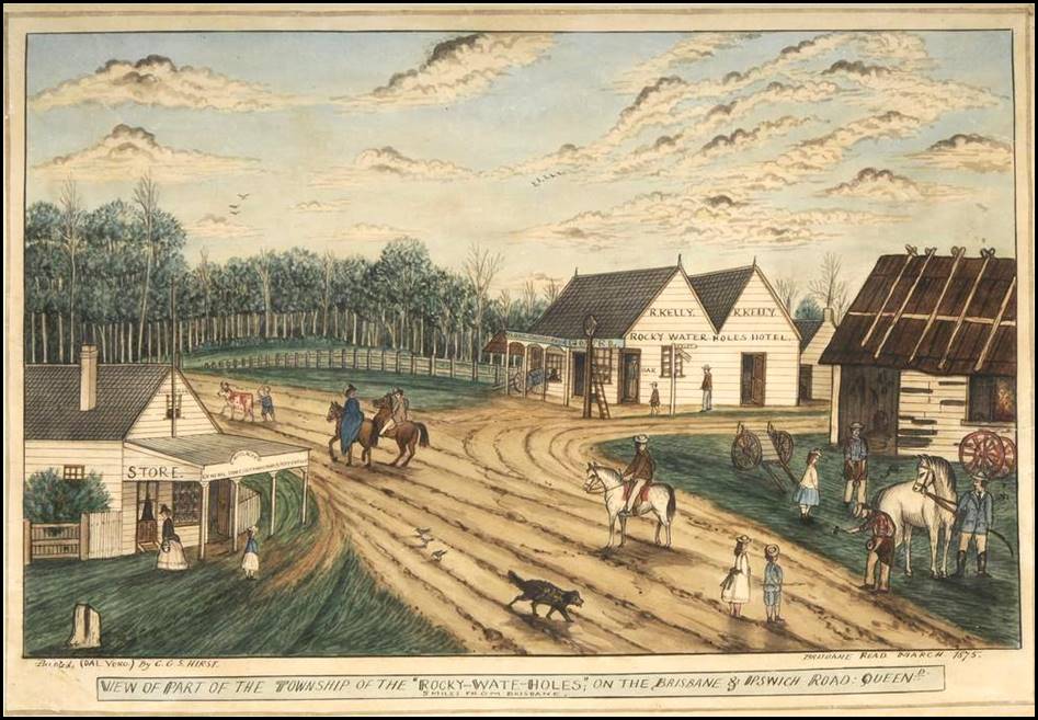
Part of the township of Rocky Water Holes 1875.
Water colour and pen and ink over pencil by English-born itinerant Australian artist Charles Gordon Sebastian Hirst (1826-1890).
Downloaded from Vintage Queensland Photos on a Facebook posting.
Surveying in Queensland 1878-circa 1913
George McDonald worked as a licensed surveyor in Queensland for some 35 years; from August 1878 based in Brisbane until circa 1913 (or even early 1914) when based at Gladstone. During this period, he undertook a prodigious amount of survey work; signing over 1 500 survey plans; an average of over 40 survey plans per year. George McDonald’s early survey plans were mainly around Brisbane and outlying areas including Cleveland, Tingalpa, Capalaba, MacLean, Toombul and Bunya. Later, his surveys continued around Brisbane but also went to around Mitchell, Tamborine, Beaudesert and Winton. From the 1890s, McDonald’s surveys were mainly in the Gladstone, and Boyne River valley area but also in other places.
On page 113 of Pugh’s Queensland Almanac 1884, the list of surveyors licensed under the provisions of Section 41 of The Real Property Act, 1877 included GT McDonald, Rocky Water Holes. On the same page, GT MacDonald (sic) was included in the separate list of licensed surveyors.
On page 112 of this Almanac, the surveyor staff of the Survey Office in the Department of Public Lands listed the Surveyor-General (Tully), his Deputy (Davidson), 5 staff surveyors, 3 district surveyors (Wide Bay, Toowoomba, and Port Curtis), and 1 trigonometrical surveyor. Thus, it seems likely that many of the necessary land surveys would have been undertaken by private surveyors under contract.
Queensland Museum of Lands, Mapping and Surveying records indicated that George McDonald was never a staff employee of the Survey Office within the Queensland Department of Public Lands or successor organisations. However, it appears that George McDonald undertook surveys for the Queensland Government for over 30 years. Given his earlier experience as a staff surveyor with the Victorian Government, McDonald may have preferred to work on a contract basis.
In the early 1900s, McDonald was said to be the District Surveyor at Gladstone; perhaps this position was also on a contract basis. Below are some of the surveys that George McDonald is known to have undertaken.
On 7 March 1888, The Brisbane Courier reported that Mr GT McDonald was paid some £14 16s for surveys made on behalf of the Cleveland Divisional Board under instructions received from Mr William Montgomery Davenport Davidson, then Acting Surveyor‑General.
Also on 24 March 1888, it was reported in the Western Star and Roma Advertiser, that Mr McDonald, the government surveyor (sic) was engaged in surveying various 80 acre farms on the camping reserve about 2 miles (about 3 kilometres) north-west of Mitchell.
On 9 November 1891, The Brisbane Courier newspaper reported that Mr GT McDonald had been appointed a mining surveyor at Gladstone; the report was sourced to the Queensland Government Gazette of 7 November 1891.
In 1892, while surveying in the Boyne River valley, George McDonald took up a block in the Parish of Wietalaba which he called Cluden. This block was initially held in the name of George’s eldest child Isabel Agnes McDonald. It was located at the confluence of Cedar and Marble Creeks about 5 or 6 kilometres south-west of the (later) Wietalaba post office; see Map 6 below.
In the early 1920s, Cluden was occupied by George’s second eldest child William Alexander Fancourt McDonald who resided there until his death in 1952. After WAF McDonald’s death, Cluden was held by his elder son John Richard Fancourt McDonald (1907-1978).
On 18 January 1896, The Queenslander (Brisbane) newspaper reported that Mr GT McDonald and his son Allan McDonald had left for Bundaberg en route for Gladstone.
In early 1900, George McDonald was surveying from a camp on Calliunigal Station near Dundee (later renamed Deeford) about 5 kilometres east of Wowan in the Dee River valley about 70 kilometres south-west of Rockhampton.
In 1903, 1905, and 1908, George McDonald was listed on electoral rolls as residing at a surveyor’s camp via Miriam Vale which is about 65 kilometres south-east of Gladstone and lies to the east of the Boyne River valley but separated by the Many Peaks Range.
On page 4 of The Brisbane Courier on 12 January 1904, it was reported that Mr AA Spowers, Chief Surveyor of the Queensland Lands Department was considering offering a 3-year appointment to a surveyor position at Kuala Lumpur in the Federated Malay States to Mr ARF McDonald, a son of Mr GT McDonald of Rocklea one of the oldest and most experienced surveyors in Queensland. Mr McDonald, junior, has lately been engaged in the Rockhampton district with his father, and he is expected to arrive in Brisbane shortly when his decision with respect to the offer will be made known. (Follow‑up articles on this matter were not discovered.)
In 1907, George McDonald surveyed about 1 620 hectares of the Yarwun Scrub that was located about 20 kilometres to the north-west of Gladstone. The survey was to allow the area to be opened for selection as agricultural farms.
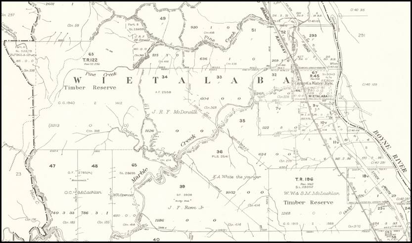
Map 6: Showing the then JRF McDonald property at Wietalaba circa 1970. Edited extract from Parish of Wietalaba map, Department of Lands, Brisbane, September 1970.
Accessed from the National Library of Australia, Bib ID: 2107016, object 1927719002.
The full map can be accessed and zoomed at this link.
In 1911, George McDonald resurveyed 11 blocks on Fairfield Station in the Boyne River valley which were to be resumed for closer settlement. For the same purpose, he also resurveyed the nearby Littlemere into 30 blocks.
On electoral rolls for 1912 and 1913 , George McDonald’s wife, Amelia Margaret McDonald, was listed as residing at Roseberry Street Gladstone while George was listed as residing in Gladstone. Amelia McDonald was last discovered as residing at Rocklea on a 1908 electoral roll listing. However, Mrs McDonald was reported in The Brisbane Courier on 16 January 1910 as being away from her Rocklea home to visit her son and his wife at Stanthorpe until March 1910.
Retirement circa 1914
After surveying in the Gladstone district for many years, age necessitated George McDonald’s retirement from his strenuous field surveying life. Circa 1913 or 1914, he went to live at Stanthorpe where his second son, James Edward Fancourt McDonald, was a medical practitioner. At Stanthorpe, George McDonald contracted a chill and he was compelled to move to the Brisbane bayside. Sadly, this change came too late for recovery and after some months of ill health George McDonald died at Wynnum South on 29 January 1915.
George McDonald District Surveyor Gladstone circa 1909.
Edited image from Queensland Museum of Lands, Mapping and Surveying.
Vale
As mentioned, George Thomas McDonald died on 29 January 1915 at Carlton Terrace in the bayside Brisbane suburb of Wynnum South (Manly), he was 79 years of age. George was survived by his widow Amy and 6 of their 8 children: daughter Isabel (Mrs Cecil Henry Foott) and sons William, James, Allan, George, and Sydney and by their families. (Young daughter Christina (Daisy) and infant son Thomas had pre-deceased him.) George Thomas McDonald’s remains were interred at the nearby Hemmant Cemetery off the Hemmant-Tingalpa Road, in the plot Monumental A. 7. 40; his grave is unmarked.
George McDonald’s widow, Amelia Margaret (Amy) McDonald died at Wickham Terrace Spring Hill (Brisbane) on 24 July 1939, she was 94 years of age. Amy was survived by sons William, James, Allan and Sydney and by their families. (Her other 4 children had pre-deceased her.) Amy McDonald’s remains were conveyed from the John Hislop and Sons Funeral Chapel at 17 Peel Street South Brisbane at 10:00 am on 25 July 1939 to Mt Thompson Crematorium at Holland Park West. There is a plaque for Amelia Margaret McDonald at Mount Thompson Memorial Gardens and Crematorium; register no 2638.
Acknowledgements
During the research and preparation of this article the following people generously provided assistance:
· Kaye Nardella, Senior Curator, Queensland Museum of Lands, Mapping and Surveying
· Bill Kitson, former Senior Curator, Queensland Museum of Lands, Mapping and Surveying
· Paul Wise OAM, founder, operator, and editor-in-chief of the XNatmap web site.
The author gratefully acknowledges the kind assistance provided by each of these people.
Some of George McDonald’s published letters
Letter No 1: Road to Gipps Land
(from The Public Lands Circular, 27 December 1862.)
The accompanying report has been received from Mr Assistant-Surveyor McDonald, of the progress he has made with his survey of a road to Gipps Land, from Yallock to Morwell.
Survey Camp, Yallock
4 December 1862.
Sir, I have the honour to forward herewith a plan of my survey for a new line of road from Melbourne to Gipps Land, viá Cranbourne and Yallock, which I propose shall diverge from the Lower Gipps Land road (now the South Gippsland Highway) at Tobin Yallock bridge (now near Lang Lang) and join upon the upper road (now the Princes Highway) at the Morwell bridge (over the Morwell River on the western outskirts of Morwell).
In compliance with your instructions, I made it my duty to keep along the Dividíng Range-a task of great difficulty, on account of the irregularity of the country and of the density of the scrub. I have nevertheless succeeded in accomplishing it; and am most happy to state that, with the exception of a few places, an excellent road may, when cleared, be had to Gipps Land.
The range, as you will observe on this plan, is crooked, yet the distance is very little in excess of that by the Fern-tree Gullies, while in every other respect this road will be infinitely superior, as there are no creeks to cross, consequently no bridges will be required. The ground is almost all good and firm, so that travelling may be performed with safety and comfort at all seasons of the year.
The cost of clearing will be the chief item of expenditure, but that, together with the expense of making a few side cuttings at the places indicated below, should not exceed £10,000. Indeed, for that sum I consider that a thoroughly good road, one chain wide, could be made, which would be practicable for travelling day or night. I specify a road of a chain wide because the ridge for a large proportion of the distance would not admit of one wider, and in one or two places it cannot without levelling be made wider than forty five or fifty feet.
One of the greatest objections by the public to this road will be the scarcity of feed for stock, there being a length of nearly fifty miles in which the only herbage to be obtained is ferns, sword-grass, and a small quantity of creeping grass, which last in some places climbs from bush to bush, making travelling very painful work to the pedestrian. Even were the grass plentiful, the density of the scrub would prevent advantage being taken of it. But as the soil is generally good, I have little doubt that in the course of time hotel keepers along the road will clear and sow paddocks with grass for the accommodation of themselves and others.
Although no creeks are crossed by the road, yet there are few points of it at which water cannot be obtained at all seasons of the year, by clearing a short distance to the creeks on either side
(Here follows a list of points at which improvements are suggested, plan of which can be seen in the Board of Land and Works office.)
I have now seen a large portion of this country, and find a great similarity in it. Everywhere the scrub prevails, so that no view of any extent can be obtained, not even from the highest hills. Nature generally presents her shady side in this district, as the face of the sun is generally veiled by the scrub. Indeed, during the few days I was engaged in the open country at the Morwell, I found the glare most oppressive, and was glad to get back to the scrub again.
Bush fires have destroyed a large quantity of the timber, which now looms round on every side like huge gaunt skeletons. The look is not the worst, however, as branches are constantly dropping with a force considerably increased by a fall of two hundred and fifty or three hundred feet. At one of my camping places a limb fell upon the mess tent, and almost frightened the life out of the men in the adjoining tent. Fortunately, no one was hurt.
During the winter and after a heavy fall of rain the earth loosens at the roots of the dead trees, when large numbers of them fall with a crash, which at a distance resembles the sound of a cannon. Several times after storms I have been obliged to send back men to clear the logs from the track, and the carter invariably carries an axe when going for stores.
I observed only one place which appeared to have escaped the fires, and there the timber attained a magnificent size, the scrub also was large in proportion and tolerably open but I have invariably found where the timber was dead the scrub was dense, and the converse.
I have met with no surface indication of gold; but at a creek during my return from the Morwell one of the men made shift to wash two pannikinfuls of earth from the bed of the creek, in the lid of the billy, and found a large percentage of black sand; indeed, I thought he had got several specks of gold, which on close examination proved to be unfounded.
As tin ore, or black sand, as it is generally called, is frequently found in conjunction with gold, and by experienced miners is considered a good indication of that metal, gold may yet be found when more perfect appliances and greater care are brought to bear upon the search for it.
A short distance lower down the same creek I found a quantity of lignite.
At a point marked on the plan, where a tree had been blown down, exposing part of the rock, I found a vein of soft earthy coal about three inches thick, and fourteen inches wide, besides three or four smaller veins about half an inch in thickness. I put one of my men to clear off the débris, but made no further discovery.
The scenery in many of the gullies is of a most charming description, and were it not for the difficulties of access, would well reward some of our distinguished artists for visiting. I trust, however, that the time is not far distant when they may do so with ease. The immense quantities of fern-trees, with the innumerable forms and shades of the gums, lightwoods, wattles, musk, hoyles, and various other small shrubs, together with the gracefully tapering form of the sassafras, combine to form scenes of the most enchanting beauty, the description of which is utterly beyond the power of pen or pencil.
I beg to state that I have the black sand, also specimens of the coal and lignite, and trust shortly to have the honour of submitting them for your examination.
Your most obedient servant,
GEORGE T. McDONALD.
Assistant-Surveyor.
(To) C. W. Ligar, Surveyor-General.
From: The Argus (Melbourne) newspaper Thursday 1 January 1863, Page 6 at: https://trove.nla.gov.au/newspaper/article/6482251
Letter No 2: Coal Thirty-Five Miles Inland
The following letter, from Mr George McDonald, Assistant-Surveyor, to the Surveyor-General, is published, with a view of leading to further examinations by private individuals of the locality indicated, and to show that the coal formation extends over a very large area inland from the seams at Cape Patterson.
Survey Camp, Yallock
16 May 1863
Sir,—I have the honor to inform you that while employed on the exploration of a road from Melbourne to Gipps Land, I discovered a seam of coal on the northern side of the Dividing Range*, about thirty-five miles N.N.E. of Cape Patterson. The seam is six inches thick, dips about five degrees N.W. and is apparently of very good quality, burning very well. The coal found by me is the first that has been discovered on the north side of the watershed of the Bass River, and is, I believe the most northerly seam coal that has been discovered in this colony. Herewith I have the honor to forward a specimen for your inspection.
I have the honour to be, Sir,
Your most obedient servant,
GEORGE T. McDONALD.
(To) C. W. Ligar, Esq., Surveyor-General.
From the Mount Alexander Mail (Castlemaine) Tuesday 26 May 1863, Page 3 at: https://trove.nla.gov.au/newspaper/page/22189998
Letter No 3: Discovery Of Good Soil Where A Large Swamp Was Supposed To Exist.
(from The Public Lands Circular, 10 June 1863)
The following letter, from Mr Assistant-Surveyor McDonald to the Surveyor‑General, is published as indicating good soil where a large swamp was supposed to exist:
Survey Camp, Yallock
15 May 1863.
Sir, - have the honour to inform you that, in compliance with your instructions, I have surveyed a number of lines between the upper road to Gipps Land and the proposed new road to the same district, for the purpose of ascertaining the nature of the country between those roads.
Hitherto it has generally been considered that the country between was occupied by either the Koo-Wee-Rup or the Moe Swamp, the general opinion being that those swamps were connected-one flowing eastward, the other to the west. I have found, however, that such is not the case, but that the country, instead of being a wet and impenetrable swamp, is dry and hilly, the hills rising gently and forming a succession of wide valleys. By the lines which I have surveyed the dimensions of the Great Swamp are considerably reduced and I am inclined to think that by further examination its extent, as shown on the old maps, would be still further contracted; in fact, I believe that the only foundation for the previous opinions as to the existence of the so-called Great Swamp is a narrow chain of swamps on the west and north-west of its supposed position, formed by the overflow of the Tarwin (sic) and Buneep (now called Bunyip) rivers.
The soil of the largest portion of the country over which I passed is of a very rich description, being formed principally of rich decomposed volcanic rock: the remaining part is inferior, being a clay loam formed by the disintegration of a sedimentary rock. The change is instantly perceptible, being marked by a corresponding change in the vegetation, which, from being straight and dense, becomes open and stunted on the poorer soil.
The scrub is not so dense as on the top of the Dividing Range*, and is sufficiently open to permit the passage of wild cattle, a few of which I saw, and numerous traces of others, occasionally in places which I would imagine were impenetrable to animals so large.
A plan of my survey, with description of the soil, timber, &c., I have drawn upon the map of the proposed road to Gipps Land.
I have the honour to be, Sir,
Your most obedient servant,
George T. McDonald,
Assistant-Surveyor.
(To) C. W. Ligar, Esq., Surveyor-General
*As noted previously, it was in fact the western section of the Strzelecki Ranges that are separated from the Great Dividing Range by the La Trobe River valley.
The Argus (Melbourne) Friday 12 June 1863, Page 6
https://trove.nla.gov.au/newspaper/article/6486501
Letter No 4: Another Black Wednesday Victim.
To the Editor of The Argus.
Sir,-In leaving Victoria to make a new start in life elsewhere, I desire your kind permission to bring under the notice of the public one more of the many cases of cruelty and injustice inflicted upon one of the late civil servants by our present rulers. I shall state but the barest facts in the fewest words possible, and leave it to your readers to make their own comments.
After 20 years in the Government service, I was one of those whose services were dispensed with on Black Wednesday, without a moment's warning. About a week after that memorable day, I went to the head office of the department in which I had been engaged to ascertain if possible what was proposed to be done in reference to re-appointment. I saw the permanent heads of the department, and was told to keep quiet for a short time, as I was one of the dismissed district surveyors who were to be re-appointed. I waited for about six weeks longer, and seeing then no more probability of the re-appointments being made than in the first week after the dismissals, I got tired of hanging on and wasting my time in idleness, so again went to town with the intention of commencing work on my own account as an authorised surveyor.
I saw the surveyor-general, and told him what I proposed doing, when he strongly advised me to wait for a week or ten days longer, as matters would then be settled, and I was certain to be re-appointed. I also learned from other sources in the office that I was one of the dismissed district surveyors recommended to be re-appointed by the surveyor-general in his report on the department submitted to the Minister, indeed, it was generally known through the office that I was to be re-appointed. I returned home contented to wait in the certainty of being re-appointed, and waited on in daily expectation, only to find at last that the recommendation of the permanent head of the department had not been confirmed in my case, and that I had in consequence lost upwards of three months' valuable time to no purpose.
I was greatly annoyed at the loss of so much time, and determined to see the Minister of Lands himself, and, if possible, ascertain the reason of the treatment to which I had been subjected, accordingly I called on Mr. Longmore*, first explaining to him that I had not come to ask to be re-appointed.
*(Irish-born Francis Longmore (1826-1898) was Minister for Lands in the second Berry Government from May 1877 to March 1880. Longmore then held the western Victorian seat of Ripon and Hampden in the Legislative Assembly.)
I then said that I had been nearly 20 years in the Lands department, without fault having been found with me or complaint made against me, that I had always honestly performed my duties irrespective of politics or parties, that I had never interfered in political matters, and that as I was aware of no fault that I had ever committed I would be obliged if he would kindly inform me why I had not been re-appointed in accordance with the recommendation of the permanent head of the department.
In reply, Mr Longmore informed me that there are times and seasons when it is not expedient to give reasons, at the same time telling me that, as I had a profession, I was not so badly off as many others whose services had been dispenscd with, but who had no profession to fall back upon.
Of course, I was deeply grateful to Mr. Longmore for his explicit reply to my inquiry, and duly thankful for my good fortune in having a profession to fall back upon, for which latter, however, I was in no way indebted to his good offices. As Mr. Longmore, by his refusal to give the reason why I had not been re-appointed, virtually admitted the only reason which he could have given, but dare not, may I be permitted to state what that reason was, and I can do so the more fearlessly that it is notorious to every one at all acquainted with the facts. My only crime was that I was a family connexion of the President of the Legislative Council, and that was the sole reason that could have been given why, after 20 years of faithful service, during which I had given satisfaction to my superior officers and the public, I had not been reappointed, as recommended by the permanent head of the department in his report to the Minister on the proposed reorganisation of the department.
I will not trespass further on your space, well knowing that if every case of hardship and injustice done to the civil service by our present rulers was detailed, even your columns would be inadequate to meet the space required.
Yours, &c.,
GEORGE T. M'DONALD,
Late District Surveyor, Castlemaine.
Monument Hill, Castlemaine, 12 June 1878
The Argus, Friday 14 June 1878, Page 6
https://trove.nla.gov.au/newspaper/article/5936348
The children of George and Amy McDonald
As mentioned above, George and Amelia (Amy) McDonald had 8 children, namely:
Isabel Agnes McDonald (1872-1926) was born at Castlemaine, Victoria. Isabel died on 29 December 1926 at the Commandant's quarters in Victoria Barracks, Brisbane after being in ill health for some time; she was about 54 years of age. At Moorooka (Brisbane) on 15 October 1901, Isabel had married the then Captain Cecil Henry Foott (1876‑1942) of the Royal Australian Artillery (subsequently an Engineers officer who served in World War I and later became Brigadier-General CH Foott CB); they had 3 children. About 7 years after Isabel’s death the then Colonel Foott remarried.
William Alexander Fancourt McDonald (1873-1952) was born on 17 February 1873 at Castlemaine, Victoria. In 1899, William McDonald took up a 4 000 acres (1 619 hectares) selection in the Boyne River valley about 60 kilometres south of Gladstone. He named his selection Ubobo, apparently after the water hole Euboba. Around 1920, as the 21-year leases expired on Ubobo and other local cattle stations, the land was resumed for closer settlement under the Ubobo Soldier Settlement scheme. William McDonald was left with only the homestead area which was too small to be viable, so he dismantled his house and moved it in sections by wagon to Cluden at Wietalaba, about 16 kilometres to the north, where is was re-erected. (Cluden had been taken up in 1892 by GT McDonald under his daughter Isabel’s name.) William McDonald died on 2 January 1952 at the Gladstone District Hospital in Central Queensland after a short illness, he was 78 years of age.
At the Harpur Family’s Boyne River valley property Hybla on 27 July 1904, William married Ruby Gertrude Harpur (1882‑1950). It was a double wedding with Ruby’s twin sister Violet Blanche Harpur (1882-1946) marrying William Hamilton Maxwell (Max) Dunlop (1873-1954). William and Ruby McDonald had 4 children; their 2 sons served during World War II, see Attachment C. Ruby’s parents, Richard Donovan Speer Harpur (1841‑1908) and his wife Frances Clara Harpur née Douglas (1850-1923), were pioneers in the Boyne River valley.
Christina Annie (Daisy) McDonald (1875-1883) was born at Castlemaine, Victoria. Sadly, Daisy accidently drowned at 8 years of age on 8 January 1883 near her family home Lumeah at Rocky Water Holes (later named Rocklea) in western Brisbane.
James Edward Fancourt McDonald (1876-1954) was born at Castlemaine on 9 April 1876; he died suddenly in his residence at 15 Curzon Street East Toowoomba on 3 May 1954 at 78 years of age. James studied medicine at the University of Melbourne; gaining his MB in 1899 and his BS in 1900. He joined the Australian Army Medical Corps as a Lieutenant in 1904 and was promoted Captain that year; he moved to the Reserve circa 1907. In 1905, Dr James McDonald was a medical practitioner at Wynnum in Brisbane’s bayside and in 1908 was a medical practitioner at Dalby on the Darling Downs about 180 kilometres west of Brisbane.
Dr McDonald enlisted in the Australian Imperial Force in April 1915 and was then practising at Stanthorpe on the southern Darling Downs about 170 kilometres south-west of Brisbane. He was posted as a Captain (medical practitioner) with the 1st Australian General Hospital that was based at Heliopolis in Egypt from January 1915 to March 1916 when it shifted to Rouen on the River Seine in France about 110 kilometres north-west of Paris. Captain McDonald arrived at Heliopolis on 6 April 1916 and presumably then moved to Rouen, On 7 September 1916 he was admitted to the 2nd Red Cross Hospital at Rouen suffering from pulmonary tuberculosis and enteric. He was soon transferred to England where he was also treated for bronchitis and influenza. He departed Southampton for return to Australia on 16 October 1916 and arrived at Melbourne on 2 December 1916. Captain McDonald’s appointment with the AIF was terminated on 7 March 1917 and he was awarded a war pension.
In 1921, Dr James McDonald was a medical practitioner at the Willowburn Asylum at North Toowoomba. By 1937 (if not earlier), he was the medical superintendent at the then Willowburn Mental Hospital. By 1949, Dr James McDonald was practising as a psychiatrist in Toowoomba but retired prior to his death in 1954. At Castlemaine on 29 January 1903, James McDonald married Olive May Williams (1877‑1942); they had 3 children. In Queensland on 24 July 1944, James McDonald married Ethel May Walden (1894-1970).
Allan Robert Fancourt McDonald (1878-1939) was born at Castlemaine and died at New Farm (Brisbane) on 29 October 1939 after a long illness; at about 61 years of age. In Queensland on 16 May 1912, Allan married Alice Coralie Mackay (1877-1977) who was a nurse; they had 2 children. By the mid-1890s. Allan McDonald was working as a surveyor with his father including in the Boyne River valley south of Gladstone (1896) and at Dundee south-west of Rockhampton (1900). From 26 March 1900 to 21 December 1900, Allan McDonald worked in the Computing Branch of the Survey Office in Brisbane.
Allan McDonald was registered as an Authorised Surveyor in Queensland on 19 June 1902. Afterwards, Allan worked as a surveyor around Miriam Vale (1903, and 1905), Milton Station in the Boyne River valley (1908, 1912, and 1913) and also at Clermont (1913). (Taken up in 1853, the Milton run covered some 659 square miles or about 1 700 square kilometres.) By 1917, Allan McDonald had become a stock and station agent and resided with his wife Alice at Miles (1917), Townsville (1919), and West End (Brisbane) (1921). Later, Allan became a commission agent in Townsville (1930 to 1937).
Thomas Herbert Fancourt McDonald (1880-1881) was born at Rocky Water Holes (later named Rocklea) in western Brisbane on 11 July 1880. Sadly Thomas died as an infant at his family home Lumeah at Rocky Water Holes on 12 April 1881, he was just 8 months old.
George St John Fancourt McDonald (1882-1918) was born at Rocky Water Holes (later named Rocklea) in western Brisbane on 23 September 1882. He was educated at Brisbane Boys Grammar School. George became a professional soldier; joining the Royal Australian Artillery on 1 April 1904. Then holding the rank of Captain, at St George’s Church Queenscliff, Victoria on 25 April 1911, he married Gladys Erina Ochiltree (1886-1966); they had 2 children; both sons who served during World War II with the eldest killed in action, see Attachment C. George McDonald enlisted in the Australian Imperial Force on 16 June 1915 and served overseas during World War I. He was awarded the Distinguished Service Order (on 1 January 1917) and was also mentioned in despatches. Tragically, on 22 March 1918, George died of wounds to a leg sustained that day during enemy shelling of his headquarters in Belgium.
Major George McDonald then commanded the 2nd Australian Sige Battery in the 36th Australian Brigade, Royal Garrison Artillery. He was treated for his wounds at the 11th Casualty Clearing Station. The remains of Major G St J F McDonald DSO were buried in the Godewaersvelde British Cemetery (Plot I, Row M, Grave No 15). The cemetery is located near the Belgium border in northern France, about 220 kilometres north of Paris and about 33 kilometres south-east of Dunkirk.
Sydney Fancourt (Mac) McDonald (1885-1947) was born at Rocklea on 18 November 1885 and died on 8 August 1947 at Craigston, 217 Wickham Terrace Spring Hill (Brisbane). Sydney attended Rocklea State School, Brisbane Boys Grammar School and won a scholarship to the University of Melbourne where he studied medicine, taking his MB in 1909, BS in 1910 and MD in 1913. He was the first paediatrician within the Faculty of Medicine at the University of Queensland.
Sydney McDonald travelled to England in 1914 for postgraduate study also in 1914, he enlisted with the Royal Army Medical Corps and was posted to the 4th (British) General Hospital at Versailles in France. He served as an anaesthetist and radiographer at that hospital and later at the 33rd and 51st Casualty Clearing Stations and the 46th Stationary Hospital. He was mentioned in despatches in 1916. After the War, Sydney obtained a pilot’s licence and took an interest in both civil and military aviation medical matters. As a paediatrician he was an early advocate of the need to remove lead from paint to protect children’s health and was also involved in the treatment of poliomyelitis in children. He was commissioned as a Wing Commander (Service No 1163), Royal Australian Air Force in 1937 and became a Group Captain in the Medical Branch in 1941; a rank he held at the time of his death.
Sydney McDonald married twice but there were no children from either marriage. At St Luke’s Parish Church in Paddington (London) on 27 July 1916, Sydney married Marjorie Caroline (Madge) Peck (1883‑1940); Marjorie was a daughter of Victorian school teacher Henry Ffloyd Rutherford Peck (1857‑1915) and his wife Caroline Peck née Allan (1854-1942). Marjorie had served in France as a charge sister at the Anglo-French Red Cross Hospital at the Astoria Hotel in Paris. For her war service, Marjorie was awarded the Medal of Honour of the French Red Cross and the Medaille Reconnaissance Francais. Marjorie died in Brisbane on 26 October 1940 after being in indifferent health for some years. On 18 December 1941, Sydney married Annie Emilie Jane (Jane) Darvall née Goertz (1893-1980). As a trained nursing sister, Jane Darvall had served with the Australian Voluntary Aid Detachment in England between November 1916 and March 1919.
Some of George and Amy McDonald’s descendants’ war service
This attachment provides some brief glimpses of the contributions that just a few of George and Amy McDonald’s descendants were known to have made to Australia through active service during times of war. However, it should be noted that this list may not be complete and other McDonald descendants may have also given war service.
Some grandsons who served during World War II
John Richard Fancourt McDonald and his younger brother Ronald William Fancourt McDonald were the 2 sons of George and Amy McDonald’s eldest son, William Alexander Fancourt McDonald (1873-1952) and his wife Ruby Gertrude née Harpur (1882‑1950). These 2 grandsons served during World War II as outlined below.
John Richard Fancourt McDonald (1907-1978)
William and Ruby McDonald’s eldest son, John was born at Ubobo in 1907 and died at Cluden, Weitalaba in 1978; both locations were family properties in Central Queensland’s Boyne River valley south of Gladstone. On electoral rolls from 1928 to 1943, John Richard Fancourt McDonald was listed as residing at Cluden, Weitalaba as a jackeroo.
In August 1943, John McDonald married Mt Morgan-born Claudia Anne (Annie) Wham (1905‑2005); they had 3 children. (At the time of her marriage, Annie was working at the 112 Australian General Hospital at Greenslopes in Brisbane. Annie’s youngest brother, 426407 Flight Sergeant Dudley Wham RAAF (1921‑1944), was killed in action over Germany on 12 December 1944 when his 149 Squadron (RAF) Lancaster bomber was shot down by a fighter near Dortmund during a daylight raid on Witten.)
At Rockhampton on 25 March 1941, John McDonald enlisted in the Second Australian Imperial Force, Service Number QX20202, and underwent initial training at Redbank. He was promoted Acting Corporal on 1 July 1941 and on 8 July 1941 was transferred to the No 7 Infantry Training Centre at Foster (that was near the Centre’s Tidal River camp on Wilson’s Promontory in Victoria). No 7 was in fact a commando training centre. At Tidal River on 24 September 1941, Corporal McDonald was promoted Acting Sergeant and transferred to 3 Independent Company at Foster and detached for special duty.
After the above detail, Sergeant McDonald’s service record becomes unclear in places. Part of his record is closed and cannot be opened under provisions in the Archives Act 1983. As with the Department of Veterans’ Affairs nominal roll, the service record mentions A/Sergeant McDonald was with the 2 Independent Company. However, the service record does not give dates for his time with this unit or when he left 3 Independent Company.
His service record states Acting Sergeant McDonald arrived at Katherine, Northern Territory on 28 October 1941 and departed Katherine on 1 September 1942. His service record gives no other details until 9 February 1943, when he was evacuated to 112 Australian General Hospital in Brisbane. Both 2 and 3 Independent Companies were commando units that staged at Katherine.
On 17 December 1941, as part of Sparrow Force with the 2/40th Australian Infantry Battalion, 2 Independent Company arrived in Timor and remained there in an heroic guerilla warfare campaign against Japanese forces until evacuated during December 1942 and January 1943. The absence of any entries in McDonald’s service record between October 1941 and February 1943 may well indicate he was in Timor during this period.
However, if Acting Sergeant McDonald was still serving with 3 Independent Company, he would have left Katherine in December 1941 when this Company was sent to garrison New Caledonia to assist the Free French people there. The New Caledonia garrison was a temporary measure until relieved by a much larger American division and the Company was withdrawn and returned to Australia at the start of August 1942. However, absence of any service record mention of this or the 3 Independent Company’s deployment to New Guinea in February 1943, seems to indicate that it was more likely McDonald served with 2 Independent Company in Timor.
On 14 March 1943, Acting Sergeant McDonald’s medical classification was amended to B by a medical board. On 8 March 1943, he was transferred to 1 Australian Commando Training Battalion, stationed in Queensland. On 10 October 1943, John McDonald was transferred to the 4 Reinforcement Training Battalion (Jungle Warfare) at Cunungra on Queensland’s Gold Coast hinterland and remained there until marched out for release to industry on 17 July 1944. He was discharged with the rank of Private at Redbank on 20 July 1944.
After the War, John McDonald together with his wife Claudia, returned to the family property Cluden in the Boyne River valley. They were listed on electoral rolls between 1949 and 1977 as being occupied as a jackeroo and in home duties, respectively. As mentioned above, John McDonald died at Cluden in 1978, he was 71 years of age. Claudia McDonald died at Gladstone in 2005 at 99 years of age.
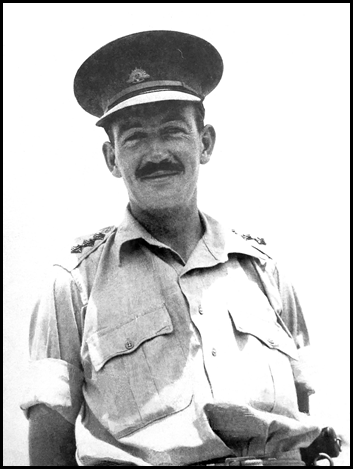
The then Captain Ronald William Fancourt McDonald early 1940s.
Edited Lani Russel image from family tree on Ancestry web site.
Ronald William Fancourt McDonald (1910-1991)
William and Ruby McDonald’s youngest son and John’s younger brother, Ronald, was born at Rockhampton in 1910 and died at Maleny in 1991 at 80 years of age. In November 1938, at Fairlight House, Fairlight on Sydney’s northern beaches, Ronald married Elizabeth Clementina MacKay (1910-2007) who was born at Oban, Scotland and died in Canberra. Ronald and Elizabeth McDonald had 5 children.
RWF McDonald joined the Royal Military College at Duntroon as a cadet in 1928 and was promoted to the rank of Lieutenant in November 1930. By the mid-1930s, Ronald had joined the Commonwealth Department of Trade and Customs in Sydney as a clerk in the Statistical Branch and was later promoted to Wharf Examaning Officer.
RWF McDonald enlisted in the Second Australian Imperial Force in Sydney in October 1939; Service Number NX91 and served with the 2/3rd Australian Infantry Battalion and rose to the rank of Major.
As part of the 6th Australian Division, 2/3rd Battalion and the then Captain McDonald served in the Middle East from February 1940, including in the major battles at Bardia and Derna as well as the Siege of Tobruk. At Tobruk, Captain McDonald was awarded the Military Cross for acts of gallantry and conspicuous devotion to duty against the enemy on 21 January 1941. Later, with the 2/3rd Battalion, Captain McDonald took part in the campaign in Greece during March-April 1941.
Between June 1941 and January 1942, Captain McDonald and the 2/3rd Battalion joined the 7th Australian Division for the campaign in Syria and Lebanon and fought around Damascus. Between April and August 1942, the 2/3rd Battalion was part of the garrison at Ceylon (Sri Lanka). Captain McDonald was promoted Major in September 1942.
Major McDonald and the 2/3rd Battalion then went to New Guinea where the first campaign, during September-December 1942, was against the Japanese in an advance along the Kokoda Track to the northern beachheads. During this campaign, the Battalion fought in major engagements at Eora Creek (22‑28 October 1942), Oivi (5-12 November 1942), and on the Sanananda Track (21 November-19 December 1942). After re-grouping in North Queensland during 1944, Major McDonald and the 2/3rd Battalion returned to New Guinea to clear the Japanese from the Aitape-Wewak area between December 1944 and August 1945; it was their last operation during the War.
Major McDonald was discharged from Army service on 8 October 1945 and the 2/3rd Australian Infantry Battalion was disbanded on 8 February 1946.
From electoral rolls, after the War, Ronald and Elizabeth McDonald and their family lived at Narooma (1949) where Ronald was an insurance agent; at Young (1958) where Ronald was an agent; and at Glen Donald, Bumbaldry (east of Glenfell) (1963-1972) where Ronald was a farmer. Later the McDonalds resided in Mountain View Road at Maleny.
George and Erina McDonald’s sons in World War II
Hugh Fancourt Graham McDonald and his younger brother Ian Ochiltree Fancourt McDonald were the 2 Victorian-born sons of George and Amy McDonald’s fifth son George St John Fancourt McDonald DSO (1882-1918) and his wife Erina Gladys née Ochiltree (1886-1966) (through her sister Sybil’s marriage, Erina was a sister‑in-law of Lt‑General Sir John Lavark (1885‑1957) who was a former Governor of Queensland). These 2 grandsons served during World War II as outlined below.
Hugh Fancourt Graham McDonald (1912-1942)
George and Erina McDonald’s first child Hugh (Hew) Fancourt Graham McDonald was born at Queenscliff, Victoria on 15 March 1912 and, tragically, was killed in action in New Guinea on 27 November 1942 at age 30 years. In Victoria in 1940, prior to joining the Second Australian Imperial Force on 10 May that year, Hew McDonald married Tumut-born 19-year old Betty Gordon Robertson (1920-2004). (In 1947, the widowed Betty McDonald married Melbourne-born Harry Maxwell Tyrrell (1918-2011), who served as a Lieutenant (PM2241) with the Royal Australian Navy during World War II.)
In the mid-1930s, Hew McDonald graduated from The University of Melbourne with the degrees of Bachelor of Medicine and Bachelor of Surgery. In October 1937, Dr McDonald was practising medicine at the then Brisbane General Hospital in the innner northern suburb of Herston (since 2003, part of the Royal Brisbane and Women’s Hospital). As mentioned, in May 1940, Dr McDonald joined the Second Australian Imperial Force. He enlisted at Caulfield as a Medical Officer (Captain) in the Australian Army Medical Corps, Service Number VX14704.
Between 25 November 1940 and 23 March 1942, Captain McDonald served in the Middle East with the 2/5th Field Ambulance AAMC. During this period he had several short detachments including to the 2/10th , 2/17th, and 2/25th Australian Infantry Battalions, 4 Australian General Hospital, 189th Field Ambulance (Royal Army Medical Corps), and special duty at Tripoli. After returning from the Middle East he spent about 5 months in Australia including a period in hospital being treated for jaundice. He was promoted Major on 13 June 1942.

Major Hew McDonald writing a letter home outside his gunyah at the 2/4th Field Ambulance’s Main Dressing Station at Myola on the Kokoda Track in October 1942.
Edited image by NX34655 Captain Alan Oliver Watson AAMC (1919-1993); Australian War Memorial Accession Number P02424.052.
On 31 August 1942, Major McDonald embarked in Brisbane for Papua New Guinea as a Medical Officer serving with the 2/4th Field Ambulance, Australian Army Medical Corps. After transferring in Townsville, he disembarked on 9 September 1942. Tragically on 27 November 1942, during the Battle of Buna–Gona, Major McDonald was killed in action when Japanese aircraft strafed and bombed the the 2/4th Field Ambulance's main dressing station at Soputa. The November 1942-January 1943 battles against the Japanese beachheads at Buna, Sanananda and Gona on Papua’s northern coast followed from the clearing of the Kokoda Track.
Initially Major McDonald’s remains were buried in Grave 40 at Soputa. In March 1943, his remains were re-buried at Grave DC 12 at the Soputa War Cemetery that was established that year as a temporary Australian War Cemetery for the casualties of the Battle of Gona and Sanananda. Afterwards, Major McDonald’s remains were placed in their final resting place at the Bomana War Cemetery near Port Moresby, Grave A6. C. 20.
On 23 December 1943, Major McDonald was Mentioned in Despatches for gallant and distinguished service in the South West Pacific area.
Ian Ochiltree Fancourt McDonald (1915–1994)
Ian Ochiltree Fancourt McDonald was born at Queenscliff, Victoria on 1 April 1915. He was the second of the 2 sons born to George St John Fancourt McDonald DSO (1882-1918) and his wife Gladys Erina McDonald née Ochiltree (1886-1966).
On a 1937 electoral roll, Ian Ochiltree Fancourt McDonald was listed as a jackeroo at Bereena, Tumblong in New South Wales about 110 kilometres west of Canberra.
On 8 July 1940, at the Scotch College Chapel in the inner eastern Melbourne suburb of Hawthorn, Ian McDonald married Katherine Brigid Cosmo (Pip) Newbery (1915-2008). They were to have 3 children: Ian, Juliet, and Hew. Pip Newbery was a daughter of St Kilda-born James Wilfrid Travers Newbery MC (1875‑1942) and his Albury-born wife Dorothy Blanche Enid (Dodo) Newbery née Chenery (1889‑1971). (Pip was born in England when her father was serving in the British Army).
In Melbourne on 14 July 1940, the then 25 years old IOF McDonald joined the Second Australian Imperial Force, in the ranks, Service Number VX34901. On 21 October 1940, he was promoted Acting Bombardier in 2/12 Field Regiment, The Royal Regiment of Australian Artillery (Royal Australian Artillery).
On 17 December 1940, Bombardier McDonald disembarked in the Middle East. He was promoted to Lance Sergeant on 12 April 1941 and was commissioned as a Lieutenant in September 1941 after undertaking a course at an Officer Training Unit in the Middle East.
Lieutenant McDonald returned from the Middle East on 27 February 1943; disembarking in Sydney. On 28 July 1943, Lieutenant McDonald embarked at Cairns for service in New Guinea and disembarked at Milne Bay (on Papua New Guinea’s far south-eastern coast) on 4 August 1943. On 28 February 1944, Lieutenant McDonald embarked at Finschhafen (on the Huon Peninsula of Papua New Guinea’s northern coast) for return to Australia (Brisbane); having been in ill health since November 1943.
Lieutenant McDonald’s commission was terminated on 10 May 1944. On 31 May 1944, Lieutenant McDonald was Mentioned in Despatches for service during the period from 1 April 1943 to 30 August 1943. During most of this period the 2/12 Field Regiment was based at Kairi on the Atherton Tablelands in North Queensland and was undergoing reorganisation and training in preparation for jungle warfare in New Guinea.
The 2/12th Field Regiment, Royal Australian Artillery was formed in Victoria in early 1940 for overseas service as part of the Second Australian Imperial Force during World War II. As a field regiment, the 2/12th deployed to the Middle East where they supported the 9th Australian Division in several battles during the North African (Western Desert) Campaign in 1941‑1942, and later undertook garrison duty in Lebanon.
The 2/12th Field Regiment is said to have had one of the most distinguished service careers of any Field Regiment during World War II. During the Western Desert campaign, the 2/12 Field Regiment operated during the Siege of Tobruk and the First and Second Battles of El Alamein. Initially, during the Siege of Tobruk, the Regiment didn't have any of its own artillery pieces and used captured Italian field guns. It was unofficially stated that the Regiment spent the most days in action, and fired more shells than any other Field Regiment present at that time.
In early 1943, the 2/12th Field Regiment returned to Australia and from August 1943 fought in New Guinea and then in Borneo (the latter after Lieutenant McDonald had returned to Australia). The 2/12th Field Regiment was disbanded in March 1946.
On electoral rolls between 1968 and 1977, Ian Ochiltree Fancourt McDonald and Katherine Brigid Cosmo McDonald were listed as graziers at Glengarry, Boynedale in the Boyne River valley of central Queensland, about 40 kilometres south of Gladstone.
On a 1980 electoral roll, Ian and Katherine McDonald were listed as residing at Mundaring (about 35 kilometres east of Perth) with no listed occupations.
Ian Ochiltree Fancourt McDonald died at Gladstone on 28 September 1994; he was 79 years of age. Katherine Brigid Cosmo (Pip) McDonald died at Gladstone on 25 November 2008; she was 93 years of age. The remains of both Ian and Pip McDonald were buried in the Calliope Cemetery, about 20 kilometres south of Gladstone.
A great grandson served in Vietnam
Duncan Paruig Fancourt McDonald
Duncan Paruig Fancourt McDonald is one of the 5 children born to George and Amy McDonald’s grandson Ronald William Fancourt McDonald MC (1910‑1991) and his wife Elizabeth Clementina McDonald née MacKay (1910‑2007). Duncan McDonald was born at The Crescent (Private) Hospital in the lower north shore Sydney suburb of Manly on 25 January 1948. When growing up, Duncan resided with his parents and siblings at Narooma on the New South Wales far south coast; then at Young in the South Western Slopes region of New South Wales (about 270 kilometres south-west of Sydney) and later on the family farming property Glen Donald at Bumbaldry (about 50 kilometres north of Young).
By the late 1960s, Duncan McDonald had enlisted, in the ranks, with the Australian Regular Army; Service Number 2183805. In 1968, as a 20-year old, Duncan McDonald was posted to Vietnam on active service with The Royal Regiment of Australian Artillery (Royal Australian Artillery). Between 4 May 1968 and 24 February 1969, Duncan served in Vietnam as a Lance Bombardier with the 102 Field Battery of the 12th Field Regiment, Royal Australian Artillery. Just 9 days after he arrived in Vietnam, Duncan McDonald was engaged in Australia’s most costly and protracted battle of the Vietnam War.
The 102 Field Battery arrived in Vietnam in March 1968 and returned to Australia in February 1969. During its 1968-1969 tour of duty in Vietnam, 102 Field Battery occupied 30 separate Fire Support Bases and fired 60 000 artillery rounds in support of Australian and allied forces’ operations. Among the actions that Duncan McDonald was engaged in was the major Battle of Coral and Balmoral in May‑June 1968; further information on this battle is provided in the Attachment D.
For its actions at Fire Support Base Coral in 1968, 102 Field Battery was awarded an honour title and became known as 102 Coral Battery. However, the Battery was disbanded in 1987.
Duncan McDonald had apparently left the Australian Army by no later than the mid-1970s. On 2 separate electoral rolls for 1977, Duncan was listed as a student. On one roll he was listed as residing in Victoria Terrace Bowen Hills and on the other 1977 roll he was listed as residing in Landsborough Terrace Toowong; both are inner Brisbane suburbs. Presumably, Duncan was then studying surveying at the University of Queensland’s St Lucia campus.
On 25 May 1979, Duncan McDonald was registered as a graduate surveyor by the Surveyors Board of Queensland. However, he did not become registered as an authorised (licensed) surveyor by that Board.
From, at least, the 1980s until possibly the early 2000s, Duncan McDonald worked with the Queensland Government’s Department of Geographic Information that became part of the Department of Lands in December 1989. With the Department of Lands, Duncan McDonald worked at Caboolture in the Northern District office of the Department’s South East Region.
Apparently, by the early 2000s, Duncan McDonald had moved to New Zealand. On 1 July 2008, the then 60 years old Duncan Paruig Fancourt McDonald was registered as a licensed surveyor by the Cadastral Surveyors Licensing Board of New Zealand. At the time of his registration, Duncan was listed as residing in Slaty Creek Road Greymouth. Greymouth is a town on the west coast of New Zealand’s South Island about 170 kilometres north-west of Christchurch.
Battle of Coral and Balmoral, South Vietnam 1968
As mentioned above, as a member of the 102 Field Battery of the 12th Field Regiment, Royal Australian Artillery, the then 2183805 Lance Bombardier Duncan McDonald was engaged in the Battle of Coral and Balmoral in South Vietnam during 1968.
The Battle of Coral and Balmoral was the Australian Army’s largest unit-level action during the War in Vietnam and is one of the most famous actions fought by the Australian Army during that war. In May-June 1968, as part of a wider United States, South Vietnamese and Australian Operation Toan Thang 1 (Complete Victory), elements of the 1st Australian Task Force were deployed to Area of Operations Surfers outside Australia’s then tactical area of responsibilities in South Vietnam’s Phước Tuy Province. (Fire Support Base Coral was a road distance of about 75 miles (120 kilometres) from the 1st Australian Task Force Base at Nui Dat.)
The 1st and 3rd Battalions of The Royal Australian Regiment were deployed to disrupt enemy forces withdrawing from their May Offensive (called the Second TET Offensive) on Saigon and the United States Biên Hòa–Long Bình base complex. Australia’s 102 Field Battery, 12th Field Regiment, Royal Australian Artillery and 161 Battery, Royal New Zealand Artillery, gave artillery coverage from Fire Support Base Coral. As major enemy actions ensued, additional support was provided from armoured personnel carriers (A Squadron, 3 Cavalry Regiment) and Centurion tanks (C Squadron, 1st Armoured Regiment), from significant aerial fire coverage as well as further artillery support from A2/35 Battery (United States), and 5/2 Air Defence Battery (United States).
Fire Support Base Coral (to support 1RAR) was occupied and partially established on 12 May 1968 in the then Biên Hòa Province of South Vietnam about 7 kilometres north of the town of Tân Uyên that was about 30 kilometres north-east of Saigon; please refer to map below.
Fire Support Base Balmoral was established (to support 3RAR) about 4.5 kilometres north of Coral on 24–25 May 1968. Infantry support at Balmoral was provided by the Centurion tanks of C Squadron, 1st Armoured Regiment, Royal Australian Armoured Corps.
The Battle of Coral and Balmoral was undertaken from 12 May 1968 to 6 June 1968. During the battle, 26 Australian personnel were killed and over 100 men were wounded. Enemy losses during AO Surfers were said to be 267 killed (confirmed by body count), possibly 60 others killed, at least 7 wounded and 11 captured.
A gun crew from 102 Field Battery, Royal Australian Artillery, firing an M2A2 105 mm Howitzer at Fire Support Base Coral in 1968.
Image taken by 3790603 Gunner Keith Stanley Foster; Australian War Memorial Accession Number P01770.015.
On 12 May 1968, Duncan McDonald, as part of 102 Field Battery, was flown by helicopter in to FSB Coral together with elements of 1RAR and 3RAR. The fly‑in did not go as planned as the initial site selection was not suitable, the distance between the 2 Batteries was excessive and the helicopter landing pads were not clearly defined. The base was laid out in an ambush configuration rather than in a defensive configuration. As a result, the fly‑in was marked by delays, confusion, and landing errors. Consequently, the perimeter defences at FSB Coral were not completed by nightfall.
At about 0230 on the morning of 13 May 1968, a rocket and mortar bombardment on FSB Coral began. A fierce enemy infantry assault followed, during which the enemy temporarily overran 1RAR mortar positions and captured 102 Field Battery's No. 6 gun. The situation was stabilised by firing splintex anti‑personnel rounds over open sights from the Battery's No. 4 gun. Accurate splintex and other ordnance fire from 102 Field Battery also prevented the enemy from dragging off one of the Australian mortars from the positions they had then overrun.
As daybreak approached on 13 May 1968, the 102 Field Battery fired more splintex rounds in support of 1RAR infantrymen, who retook the positions lost during the night. Personnel from 102 Field Battery also participated in a counter-attack that recaptured their No. 6 gun that the enemy had tried to disable. Harassed by artillery fire, air strikes and aerial gattling gun fire from a United States dragon ship aircraft, the enemy began withdrawing at around 0630, leaving 52 of their dead. Despite being heavily involved in the fighting, the 102 Field Battery suffered surprisingly few casualties, with 3 men wounded and none killed. However, the 12th Field Regiment headquarters lost 2 men killed in action and 3 men wounded in action.
The enemy launched a further ground assault on FSB Coral on 16 May 1968 and afterwards continued rocket and mortar attacks on that base. After 28 May 1968, there were no more major assaults on either FSB Coral or FSB Balmoral. However, Australian patrols from these bases continued.
Locations of Area of Operations Surfers, Australian Task Force base at Nui Dat and Saigon in 1968. Map from Virtual War Memorial Australia web site.
References
Ahearn, Ian Francis (2020), The real story: First battle of Coral; an article on Australia’s Vietnam War web site, accessed at: https://vietnam.unsw.adfa.edu.au/the-real-story-first-battle-of-coral/
Ancestry (various dates), Electoral roll and family history searches on Ancestry data bases, accessed (on subscription) from: https://www.ancestry.com.au/
Anonymous (various dates), Historical newspaper searches on George T McDonald, G T McDonald, surveyor, McDonald’s Track etc, accessed from National Library of Australia Tove search service at: https://trove.nla.gov.au/newspaper/
Anonymous (2010), McDonald’s Track, an article downloaded from the Victorian Collections web site at: https://victoriancollections.net.au/media/collectors/4f729f6197f83e03086016b0/items/4f72b05197f83e030860428a/item-media/4f72b05597f83e030860428f/original.pdf
Anonymous (2023), Our History: The Morwell Bridge settlement, an article in The Warragul and Drouin Gazettte, updated 3 February 2023; accessed at: https://www.thegazette.com.au/our-history/the-morwell-bridge-settlement#:~:text=The%20bridge%20was%20built%20in,places%20in%20his%20Devon%20homeland.
Arnold, Heather (2015), McDonalds Track, an entry on Casey Cardinia-links to our past 29 October 2015; accessed at: https://caseycardinialinkstoourpast.blogspot.com/2015/10/mcdonalds-track.html
Arnold, Heather (2017), Mickle, Bakewell and Lyall, an entry on Koo Wee Rup Swamp History 2 August 2017, accessed at:
https://kooweerupswamphistory.blogspot.com/2017/08/mickle-bakewell-and-lyall.html
Arnold, Heather (2021), George McDonald, Assistant Surveyor, and the Great Swamp, an entry on Koo Wee Rup Swamp History 31 December 2021; accessed at: https://kooweerupswamphistory.blogspot.com/search/label/McDonald%20George%20Thomas%20%281835-1915%29?m=0
Arnold, Heather (2021A), McDonalds Track-from Tobin Yallock to Morwell, an entry on Victoria's Past - Rescued and Retold 30 December 2021; accessed at: https://victoriaspast.blogspot.com/2021/
Australian Government (2023), Various searches of Nominal Rolls of members of Australia’s defence forces who had served during particular conflicts, on Department of Veterans’ Affairs web site, accessed at: https://www.dva.gov.au/recognition/commemorations/records-and-military-history/nominal-rolls/list-nominal-rolls
Australian War Memorial (undated), 102 Field Battery, an article on the Australian War Memorial web site; accessed at: https://www.awm.gov.au/collection/U53446
Barraclough, Linda (2021), M is for Morwell Bridge /Morwell West; accessed from a Facebook posting at: https://www.facebook.com/groups/1755971574632862/permalink/3131177910445548/
Butler, Graeme and Associates (2013), Mornington Peninsula Shire Thematic History, prepared for Mornington Peninsula Shire by Context Pty Ltd Brunswick; downloaded from Mornington Peninsula Shire web site at: https://www.google.com.au/url?sa=t&rct=j&q=&esrc=s&source=web&cd=&ved=2ahUKEwj0jp_K9e2BAxX-r1YBHa1NAZUQFnoECA0QAQ&url=https%3A%2F%2Fwww.mornpen.vic.gov.au%2Ffiles%2Fassets%2Fpublic%2Fnew-website-documents%2Fbuilding-amp-planning%2Fheritage%2Fdocs%2Fmornington_peninsula_shire_thematic_history_july_2013_1.pdf&usg=AOvVaw2OBkTs2L0edkXytFhGxpzV&opi=89978449
Cadastral Surveyors Licensing Board of New Zealand (2009), Report of the Cadastral Surveyors Licensing Board of New Zealand for the year ending 30 June 2009, page 26; accessed at: https://docplayer.net/34471339-Report-of-the-cadastral-surveyors-licensing-board-of-new-zealand.html
Heritage Victoria (2015), Assessment of Cultural Heritage Significance and Executive Director Recommendation to the Heritage Council, Frogmore 1 Wahgoo Road Carnegie, downloaded from: https://view.officeapps.live.com/op/view.aspx?src=https%3A%2F%2Fwww.gehs.org.au%2Fwp-content%2Fuploads%2F2020%2F08%2FHeritage-Victoria-NR-Frogmore.doc&wdOrigin=BROWSELINK
McDonald, Lorna (1988), Gladstone, city that waited, Boolarong Press for Gladstone City Council, ISBN 97809599124; extracts only provided by Queensland Museum of Lands, Mapping and Surveying, Brisbane. (Dr Lorna Lorraine McDonald OAM (1916-2017) Australian historian and author.)
National Archives of Australia (2023), Various searches of individual war service records, on the National Archives of Australia web site; accessed at: https://recordsearch.naa.gov.au/SearchNRetrieve/Interface/SearchScreens/BasicSearch.aspx
Powell, Joseph Michael (1976), Skene, Alexander John (1820–1894), an entry in the Australian Dictionary of Biography, National Centre of Biography, Australian National University; accessed at: https://adb.anu.edu.au/biography/skene-alexander-john-4587/text7537
Pugh, Theophilus Parsons (1884), Queensland Almanac, Law Calendar, Directory, Coast Guide, and Gazetteer for 1884, Gordon and Gotch, Brisbane; downloaded from TEXT Queensland web site at: https://www.textqueensland.com.au/item/journal/3b2ae5ecece624f567d1952f1716ec18
Queensland Government (2023), Various family history searches on the Queensland Registry of Births, Deaths and Marriages web site, accessed at: https://www.qld.gov.au/law/births-deaths-marriages-and-divorces/family-history-research
Queensland Museum of Lands, Mapping and Surveying (2023), List of Queensland survey plans prepared by George Thomas McDonald between 1878 and 1914; 53 page database download dated 18 August 1998.
Victoria Government (various dates), Searches of historical issues of the Victoria Government Gazette, accessed from the State Library of Victoria Online Archive 1836-1997 at: https://gazette.slv.vic.gov.au/
Victoria Government (2023), Various family history searches on the Births Deaths and Marriages Victoria web site, accessed at: https://www.bdm.vic.gov.au/research-and-family-history/search-your-family-history
Victorian Places (2023), Various Victorian place history searches on the Victorian Places web site, accessed at: https://www.victorianplaces.com.au/
Vines, Jack (2008), Coal Mining Heritage Study in Victoria, Heritage Council of Victoria, Melbourne, ISBN 978-1-74208-037-6, accessed from Heritage Council of Victoria web site at: https://www.heritage.vic.gov.au/__data/assets/pdf_file/0022/513085/Coal-mining-heritage-study-in-Victoria-Vines-2008.pdf